


Route for access to circuits from the location called Otupné above the TMR chalets. At the beginning of the conjunction, it is possible to access the dismounting routes which are not too steep in their lower parts. An interesting information is from the winter of 2020, when ski slopes called Biela put, Luton Traver and the lower part of the ski slope, named Chaletova, were covered by cross -country trails during Lock down. It is these slopes that can serve as an access to the circuit for the cross – country skiers.
Detailed route description
Dúbrava, Štátne Majetky – trail to the south-east – mouth of the Dúbravská Valley – up the valley to the south – former mining plant and mining museum.
The trail follows an asphalt road purpose-built for use by large trucks, so please exercise extra caution!
The route starts at Štátne Majetky on the outskirts of Dúbrava, a historic mining village founded in the 13th century. Your walk takes you through the Dúbravská Valley, where you’ll find five information panels along the way:
- A brief history of Dúbrava village and its early mining heritage
- Geological characteristics of the Dúbrava deposit and the environmental risks of stibnite mining
- The oldest ore extraction techniques and stibnite processing
- Mining in Dúbrava during the 20th century
- Extraction and transport in Dúbrava mines in the 20th century
Around 6 km from the village, you’ll reach the site of the former mining plant in the Paludžanka Valley, located on the northern side of the Chabenec massif in the Ďumbierske Tatras. This is home to the most important stibnite deposit in the Czech Republic and Slovakia. Besides stibnite, small quantities of gold, silver, and copper ores were also mined here in the past. Mining activity intensified significantly after 1948, when a flotation processing plant with a capacity of 50 tonnes per day was established. To transport ore to the plant, cableways were built from the Predpekelná and Dechtárka sections, one measuring 1.4 km, the other 0.5 km. Stibnite from Dúbrava was a strategic raw material for Czechoslovak arms manufacturing. In 2023, the Mining Museum opened in the building of the former mining warehouse office – known locally as the banícka faleska – where miners once gathered before heading underground. The museum, offering an exhibition on the history of local mining, is open to the public at weekends from 11 a.m. to 2 p.m. by prior telephone appointment.
Accessibility and parking
Dúbrava can be reached from the town of Liptovský Mikuláš via the local regular bus service, with the trail’s starting point conveniently located at the bus stop. If you are travelling by car, parking is available at several quiet spots along the roadside.
Accommodation and food facilities
There are several accommodation facilities in the village and in the valley that offer accommodation. Dining options are provided, whether in summer or winter, in hotel restaurants or snack bars.
The route begins at the car park near the site of the Východná Folk Festival, which takes place in early July every year. There are several parking options around the grounds, but the closest car park is right next to the main entrance. It’s a short walk – just five minutes or so – manageable for children and less mobile visitors. The site also features an observation tower, wooden sculptures, a small children’s playground, and a snack bar offering refreshments – HybajHo. Please refer to the snack bar’s website for its current opening hours (which may be restricted in off-season months).
The Májka observation tower is open daily from July to September. Outside these months, entry may be arranged by phoning in advance. Guided tours of the tower and amphitheatre in Východná by a local guide are available. This is your chance to learn fascinating facts and hear intriguing anecdotes and stories from the amphitheatre’s history.
The trail from the Demänovská Cave of Liberty to the top of Siná (1,560 m) is a popular trek through the Low Tatras. At the summit, hikers are rewarded with stunning panoramic views of the Demänovská Valley, the Liptov region, and the encircling mountain ranges. It is accessible throughout the year.
The trail begins at the car park near the Demänovská Cave of Liberty (around 870 m above sea level). From there, follow the yellow trail towards Siná. The path starts with a gentle climb through forested terrain, passing by meadows and small rocky outcrops. The yellow markers lead you to the Bôrová hoľa crossroads (1,316 m), a perfect place to pause for a short rest or refreshment. From this point, the yellow trail becomes progressively steeper, winding its way through dense woodland that gradually begins to open up.
The final section of the climb is more demanding, passing over rocky terrain. Caution is advised, especially in wet weather, as the rocks can be slippery. After roughly two to three hours (depending on how fit you are), you reach the summit of Siná (1,560 m), offering panoramic views:
- To the north, the Liptov Basin and the Western Tatras unfold before you.
- To the south, the peaks of the Low Tatras stretch into the distance.
Return by the same route, following the yellow trail back to the Demänovská Cave of Liberty. The entire trek takes approximately four to five hours and is of moderate difficulty.
Hiking tips
- Wear sturdy hiking boots and bring plenty of water and snacks.
- This ascent is best suited to experienced hikers or families with older children.
- During the summer months, start early in the morning to avoid the heat and any thunderstorms.
The ascent of Veľký Choč is one of the most interesting, but more demanding, routes in the region. It is especially sought-after because of the beautiful panoramic views from its peak.
The route is located in the Choč Mountains, and Veľký Choč is the highest peak. The route passes through the Choč Mountains Special Protection Area and the Choč National Nature Reserve. While in the forest, please try not to disturb its inhabitants and damage anything. Do not pick anything and do not leave anything behind. The Ružomberok Information Centre offers collectors Veľký Choč, Lúčanský vodopád waterfall, Kúpele Lúčky spa and Lúčanské travertíny travertines tourist stickers. Lúčanský vodopád waterfall magnets are also available.
The route is one of the more demanding ones, mainly due to the large elevation gain over short sections. The terrain is diverse, from muddy sections and rocky parts through forest paths to an asphalt road. Some of the more difficult parts are made safer with steel chains, and in some places you need to use your hands to hold on to trees, rocks or dwarf mountain pines.
Detailed route description
The route begins in Valaská Dubová at the tourist signpost next to the “Valaská Dubová, OcÚ” bus stop. Follow the blue trail leading past the wood carving of the bandit up the hill between the houses, and turn towards the rock cliff behind the municipality when the road forks. Continue along the paved road between the trees and bushes to the meadow. Below the forest there is an educational panel about the “Les” (forest) and to the right of it there is a shelter with seating. The route becomes steeper after entering the forest. After a short climb, we reach a shelter with seating and a well with water. Here the surface changes to gravel and sometimes rock, and we reach a sort of rock gate consisting of rocks on both sides of the trail, from where the slope gets even steeper. The path continues straight up the steep slope to the educational panel about “Fauna”. The route levels off a bit here, then gets steeper again until it leads us to meadows where there is an educational panel about “Flora”. Another important point on the route is the “Stredná Poľana” signpost, from where you can enjoy the views. Now follow the green trail along the edge of the mountain meadow, then turn right onto the summer route. Along the forest trail, we gain the elevation needed to reach the top. We then come out of the forest onto the sloping meadows, which take us to a dwarf mountain pine forest. The trail through the dwarf pines is short but rocky and gravelly. Not far from the top, our trail connects with the red trail, so continue along this to the top and beyond. A tourist signpost sticking out under a rock welcomes us to the peak of Veľký Choč. However, continue a few more metres to the right to the actual peak, where there is a viewing point that helps us identify the surrounding hills and an ascent log in which we can enter some information. The reward for completing the ascent is a beautiful panoramic view in all directions. Veľká Fatra, Malá Fatra, Chočské vrchy, Nízke Tatry, Západné Tatry, Vysoké Tatry, Oravská Magura, Orava, Liptov and much more can be seen from the peak if we are lucky to get good weather.
Availability and parking options
By car: Parking in the municipality is only possible in the paid parking lot at the local cemetery.
By taxi: A taxi from the city centre to the start of the route will cost you around €10.
The route is also accessible by bus, with a suburban bus from Ružomberok taking you to the starting point. Take the bus from the Ružomberok bus station to the “Valaská Dubová, OcÚ” bus stop.
Options for accommodation and meals
Safety: There are several steep climbs / descents on the route, and these can be slippery in both wet and dry conditions. Some sections in the forest pass through muddy terrain. The steeper and more difficult parts of the route are made safer with a chain. The viewpoints at the top are not secured in any way. A large part of the route leads along rocky and craggy paths with a consequent risk of ankle sprains. We thus recommend taking trekking poles and good non-slip shoes. The route is not suitable for children under 10 years old, or for people with reduced mobility.
(Náhľad mapy: hiking.sk)
Detailed route description
Babky (1566 m above sea level) is part of the Western Tatras, while the hike to them is not among the most demanding, but it is definitely one of the most beautiful. Especially the views of Liptov are worth it.
You start the hike to Babky at the beginning of the Bobrovecká valley, specifically in the Bobrovecká vápenica area, where free parking is available. The route follows the blue sign next to the calvary along the weighbridge through the Pod Babkami intersection to the Chata pod Náružím, where you can have refreshments. The route continues along the blue sign to Pod Babkami, from where you take the green sign to Babky. Grandmothers have a unique view. During the route, we can stop at a partisan bunker. This is a cave with photos and a description where the guerrillas were hiding.
Availability and parking options
There is a free parking lot with sufficient capacity right at the starting point of the route in the location of Bobrovecká vápenica.
The bus stop is about a 2.5 km walk from Bobrovecka limestone at the intersection with the village of Jalovec, which can be reached by suburban line from Liptovský Mikuláš.
Accommodation and catering options
On the way to the top, you walk past the Chata pod Náružím in Červenci, where you can have refreshments or sleep. The Mountain Hotel Mních is located near the starting point of the route. On the way from Jalovec, it is possible to visit Salaš Pastierska. In addition, there are designated sites for camping.
Detailed route description
The route is parallel to the red hiking sign, with the exception of the detour to stop 3. At the end, the educational trail leads through a high mountain environment, where you need to be especially careful in the steep part. The last information panel of the educational trail stands in the Vrác saddle about 30 minutes from its destination at the top of Veľké Choč.
Names of information panels:
1. Lúčky village
2. National natural monument Lúčanský waterfall
3. Natural monument Lúčanské travertine
4. Spa Lúčky
5. Choč – Žimerová meadows
6. Choch – forest area
7. Choč – alpine range
The information panels in the field are not marked with the name of the nature trail.
Availability and parking options
Parking is possible in the village of Kalameny.
Accommodation and catering options
You can stay in Kalameny or Lúčky.
Detailed route description
The route starts in the village of Kalameny and continues past the Kalameny lake (thermal spring), which is used for public bathing all year round. It is parallel to the yellow and, from the junction Sedlo pod Kráľová, to the red tourist sign. The route with a permanent climb leads largely outside the forest, which can be strenuous on sunny summer days. A 7 m high metal ladder and a bridge lead to the platform with the castle. There are warnings in the terrain: entry into the Liptovský Castle area is possible only at your own risk and for persons under 14 only accompanied by adults.
With good visibility, the hill and the castle offer views as far as Orava with Baba Hora, the Liptovská Basin with the Liptovská Mara reservoir, the Low Tatras and Veľký Choč (1,609 m above sea level). The castle area is a national cultural monument. The small remains of the castle (exposed foundations of the walls), which are being preserved by the local civic association Castrum Liptov, are freely accessible to the public.
Names of information panels
1. Educational trail Kalameny – Liptovský Castle
2. Flax and hemp
3. Water
4. Interesting facts about Liptov Castle
5. Forest
6. Geology of the Choč Hills
Information panels in the field (except for the introductory one) are not marked with the name of the nature trail.
There are also (three) faded information panels from the previous version of the educational trail (status in 2020) on the trail route. It is possible to return from the castle to the lake as a circuit following the (exposed and also steep) blue tourist sign (total 4.5 km to the exit in the village).
Availability and parking options
Parking is possible in the village of Kalameny or by the Kalameny lake. Parking is charged.
Accommodation and catering options
You can stay in Kalameny or Lúčky.
The educational trail Plieška (Cyril and Methodius path) will take us from the Spa Lúčky below the hill Plieška to the village Kalameny. The trail is connection between the natural thermal lake in Kalameny and the Spa in Lúčky village.
Detailed route descrition
You can also get to the Spa Lúčky by bus. The route starts at the tourist crossroads Lúčky, Aqua-Vital Park, near the restaurant Kúpeľná dvorana. However, it is both direction-way. You will go along the edge of the forest along the blue-marked hiking trail at the southern foot of Plieška Hill.
The trail is moderately challenging and can be muddy and slippery on some places in colder weather. The route is only slightly difficult due to its length, elevation and terrain. Therefore, it is suitable even for small children.
A path with three educational panels will lead you to Kamaleny village. There is a natural swimming pool called a “pit”. The nature trail begins/ends at the rebuilt and adjusted pit with warm mineral water.
Information boards names
- Great Moravia
- Saint Cyril – Constantine
- Saint Methodius
Information panels in the terrain are not marked with the name of the nature trail. The design of the first and the remaining two panels differ.
Availability and parking options
Free parking is possible at the beginning / end of the route in the Spa Lúčky, or at the thermal lake in Kalameny. There are also regular bus connections to the villages from Ružomberok town.
Options for accommodation and meals
In the villages of Lúčky, Liptovská Teplá and Kalameny there are several accommodation and catering facilities.
A lightweight circuit is gradually rising from the free parking lot next to the football field between the villages Smrečany and Žiar. You can get here by turning left at the end of the village Smrečany. In its upper part, the circuit will take you to the ski resort Žiar-Dolinky, where you can continue to the circuit “Around the Acidic Mineral Water”. You can choose the other side of the circuit for the lightweight downhill back to the village Smrečany.

The project is implemented with the financial support of the Ministry of Transport and Construction of the Slovak Republic.
The village Pavčina Lehota has been preparing tracks for several years. It is surrounded by meadows, which make it possible to realize the modification of interesting circuits. From the easiest ones for cross-country skiing beginners and families with children to the long circuit around the whole village, where even performance-oriented cross-country skiers will enjoy themselves.
The tracks are prepared exclusively on natural snow. The municipality authority takes care of them. The best entry to cross-country skiing routes with parking is the ski resort Žiarce. There is also the possibility of refreshments after a day spent on the cross – country skiing track.
After the initial climb, the circuit will bring you closer to the observation tower and then take you through the meadows with a nice view above the village of Lazisko.
The village Pavčina Lehota has been preparing tracks for several years. It is surrounded by meadows, which make it possible to realize the modification of interesting circuits. From the easiest ones for cross-country skiing beginners and families with children to the long circuit around the whole village, where even performance-oriented cross-country skiers will enjoy themselves.
The tracks are prepared exclusively on natural snow. The municipality authority takes care of them. The best entry to cross-country skiing routes with parking is the ski resort Žiarce. There is also the possibility of refreshments after a day spent on the cross – country skiing track.
After the initial climb, the circuit will bring you closer to the observation tower and then take you through the meadows with a nice view above the village of Lazisko.ž
The project is implemented with the financial support of the Ministry of Transport and Construction of the Slovak Republic.
The route is located on the cycle path along the river Váh. The ideal starting point is the Embankment of Janko Kráľ. You can park your car free of charge in front of the indoor swimming pool or in front of the ice hockey stadium or near the guest house Lodenica, which can be considered the starting point of the route.
There is a significant number of pedestrians on the track due to the multifunctional use of the cycle path. On the other hand, it badly affects the quality of the track. Due to smaller width, the track is only modified by the scooter and it is more suitable for the classical cross-country skiing technique. The route near the bridge Iľanovský bridge crosses the main road, less than a kilometer after its beginning. There is no need to turn back in this place, but after taking off the skis and carrying them across the road, it is possible to continue to the suburb Okoličné.
The modification of the track is provided by the Association of Sports Clubs Jasná LM with the support of the town Liptovský Mikuláš.
The project is implemented with the financial support of the Ministry of Transport and Construction of the Slovak Republic.
Re-opening of the ski resort Podbreziny gives the opportunity to modify the tracks in Háj Nicovô using the help of snow groomer and artificial snow.
In case of exceptional snow conditions, it is possible to modify the route from Háj to the valley Žiarská dolina. By connecting these two areas of cross-country skiing, a route up to 12 km long in one direction can be created, with an extension to the cottage Žiarska chata by 5 km more.
The planned route starts at the parking lot at World War II memorial Háj – Nicovo and follows towards the upper station of the ski lift. Here the route turns and with a gradual descent it takes us near the crossroad towards the village Smrečany. From there, the route rises again along the the route called General Kuna’s path to the main parking lot.
The route offers magnificent views of the region Liptov. Just a few meters from the upper station of the ski lift, there is a monument commemorating the victims of World War II. Cross-country skiing on the Háj Nicovô makes it possible to combine sport with learning about the history of our territory. The modification of the route is provided by the Association of Sports Clubs Jasná LM with the support of the town Liptovský Mikuláš.
The project is implemented with the financial support of the Ministry of Transport and Construction of the Slovak Republic.
You will find well-groomed trails for cross-country skiers only 3 km from the town Ružomberok in the village Liptovská Štiavnica. The starting and ending point is located about 800 meters above the end of the village near the tourist and landscape interesting formation called “Meadow Mushroom”. It is located near the tourist shelter at the begining of the valley Zemanská dolina with the possibility of comfortable parking.
You can rent cross – country skiing equipment in the village Liptovská Štiavnica in ski rent cetre ALGY SPORT. You can also ask for the professional help of the ski instructor, who will teach you the basics of cross – country skiing.
The project is implemented with the financial support of the Ministry of Transport and Construction of the Slovak Republic.
The tracks are located 200 meters above the end of the village towards the hamlet Železnô. Parking is possible right next to the main road at the turn to the natural monument Meanders of the stream Lúžňanka. The cross-country skiing track begins right at the meanders. At the beginning, it passes the newly built observation tower. From the tower you can see this miracle of nature like at your hands. iThe meanders give the impression that water flows uphill which makes this location a rarity, and a small stop here is definitely worth it.
The track then gradually rises in the corridor of the old road towards the mountain saddle Prievalec. The climb reaches its peak and turns onto a pleasant forest trail leading to the hunting lodge. This track leads partly through the forest and offers nice views of the valley and the village Liptovská Lúžna and also opposite located Low Tatras.
When you ski back downhill, it is necessary to adjust the speed referring to the snow conditions. The route difficulty itself depends on them. When snow conditions are good even a beginner can handle skiing here. Sometimes hard snow ground offers you real downhill adrenaline experience.
The track is modified by the volunteers from Sport club Liptovská Lúžna with the support of the municipality.
The project is implemented with the financial support of the Ministry of Transport and Construction of the Slovak Republic.
Jasná has been known in recent decades for its possibilities for downhill skiing. In the past, however, it was not so one-sided. Many of us have no idea that in the valley Demänovská valley, in addition to downhill tracks, cross-country racetracks with the parameters for international races were also built.
A larger sports complex with the ski jumps was also planned, which eventually fell out due to the disapproval of the Nature protection institution. Cross-country skiing has been subdued for many years in the ski resort Jasná. The progress occurred recently, when, in addition to the construction of snowmaking tanks in the locality called Zadné Vody, the terrain was also adapted for the modification of cross-country trails.
The tracks are prepared exclusively on natural snow. Due to the altitude above 1,200 m above sea level, we assume a relatively high guarantee of sufficient snow and thus the usability of prepared routes. The ski resort Jasná takes care of the traces, increasing the range of services offered to visitors.
Try other circuits in the area of Zadné vody:
Tourist circuit in the ski area Jasná Zadné vody
more information HERE
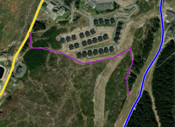
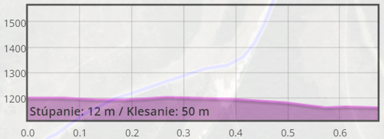
The Chalet conjunction
Download GPX file.
The project is implemented with the financial support of the Ministry of Transport and Construction of the Slovak Republic.
The resort operator promises permanently illuminated, artificially snowed and daily snow groomed circuit at the bottom of the ski lift right next to the parking lot. Its length is approximately 200 meters. As the only track in Liptov, it is obligatory to charge 4 € per person. The price is the subject to change and therefore check the current price list of the resort Demänová on their website. In addition, this track is connected to the surrounding circuits, the length and difficulty of which depends on the snow conditions. You also have the option to go through the second circuit. You can download its gps HERE.
The circuits start right next to a small circuit, lead along the road towards the ski resort Jasná and then rise above the village Ploštín to the hill of the same name. The ridge part offers pleasant views especially at sunset.
The project is implemented with the financial support of the Ministry of Transport and Construction of the Slovak Republic.
Season: ski touring season is between December 15 and April 30
Ideal conditions are: between January and March
Necessary equipment: avalanche safety gear
Route description
The route begins and ends in the village of Liptovské Revúce. This less demanding tour leads to one of the highest peaks of the Veľká Fatra mountain range – Krížna. The trail is less visited as more skiers begin their tour to Krížna at Rybie or Turecká. This, however, means that it is ideal for those who prefer off the beaten tracks and avoid crowds of tourists. The name of the peak (Krížna – “Cross”) is really apt as you can get to this destination from several places. What is more, it is the crossroads of several summer hiking routes and you can get there even along the cycling trail.
Ski touring fans love this place mainly for its wide and smooth grassy slopes. Only a few dozen centimetres are enough for perfect skiing. However, its elevation may be a slight disadvantage because a lack of snow and mild winters can considerably shorten the winter season in comparison to the High Tatra Mountains. In addition, the route begins at the elevation of 735 metres above sea level, where the snow does not stay long. That is why we recommend watching snow and also avalanche forecasts. Even though these mountains are low, there is an avalanche danger, especially in the steepest draws around the peak of Krížna. Unfortunately, there were some fatal avalanche accidents in the past. Since the route is pretty long, skiers need to be in really good shape.
Ascent
The route begins with moderate ascent through the valley called Suchá Dolina, past the lodge named Hajabačka. The trail then narrows gradually. Above the timberline, it leads towards the chalet Pod Ostredkom. After Dlhý Grúň, the route leads along the red marked ridge trail up to the summit of Krížna. This last section can be very windy and sometimes you can even see the grass. We, therefore, strongly recommend taking some spare windproof clothes. The peak itself is not open to the public as there is a fenced facility used by the Ministry of Defence. It, however, provides shelter from the wind.
Descent
When it comes to descents, there are several options. The first one copies the ascent route across Dlhý Grúň. The second option means a descent straight from the summit down to Suchá Dolina, which is more appealing as it offers wide steep slopes. However, you will need to watch out for an avalanche danger (follow avalanche forecasts at www.hzs.sk).
Points of interests on the route
There is also a via ferrata called Dve Veže situated off the route (the educational trail and the iron path – via ferrata – can be used between 15 June and 31 January, from one hour after the sunrise until one hour before the sunset).
Access and parking options
By bus: the bus stop Vyšná Revúca (the city bus coming from Ružomberok)
By car: straight from the village of Liptovské Revúce, part of Vyšná Revúca
Refreshments on the route
There are not any; we recommend taking your own food.
Accommodation options in the vicinity
Private lodging in the village of Liptovské Revúce – accommodation websites.
Useful notes and tips
+
pleasant, moderate tour
suitable also for beginners who must be in good shape
less crowded trails in comparison to other tours
–
low altitude
snow conditions must be appropriate
long route through the valley
Season: ski touring season is between December 15 and April 30
Ideal conditions are: between Februar and April
Necessary equipment: avalanche safety gear, crampons and an ice axe
Route description
Dereše is a mountain situated in the highest portion of the Low Tatras ridge. It is one of the few peaks in this mountain range the altitude of which is more than 2,000 metres. In the beginning, the trail is moderate, but its final stage leads through a steep and narrow draw. That is why you need to know how to move in crampons and use an ice axe. Most of the trail is north-facing, so the sun almost never shines there in wintertime. Therefore, the snow in this place is often powdery. In other parts of the valley, however, its surface is changed by the sun. Such shaded and steep slopes can become very dangerous, especially in December and January, when the sun rays do not fall on them yet. As a result, the snowpack is not stable. Since the steepness of the slope exceeds 35°, it is necessary to watch weather and avalanche forecasts. In addition, you need to consider movement of other skiers as Dereše is very popular with free-riders, who often come here from the nearby ski lift to Chopok.
Ascent
The route begins in the Jasná ski resort at Pošta Hotel. You will ascend the first few kilometres up the ski run called Brhliská (1,423 m.a.s.l.). While moving on ski slopes, you should always be lined up one behind the other (not next to each other) and respect other skiers. At the upper station of the ski lift to Brhliská, you will get to an open terrain and copy the track of the lift to Derešský Kotol, which is now out of use. In this part of the trail, the slope becomes steeper and there are often snow bumps carved by skiers in the winter season. However, you can still have your skis on. After about 800 metres, you will get above the dwarf pine vegetation zone, where you can enjoy the view of Derešský Kotol and the highest point of the trail. After reaching the last ski lift mast, you will need to turn right and continue the ascent straight along the draw below the peak of Dereše. Here, you will have to take off your skis and attach them to your rucksack. If the snow surface is hard, put on your crampons. Watch out for snow cornices that might form right below the ridge! If the weather is nice, you can admire breath-taking views all around. Watch out for other skiers as the draws coming down from the summit of Dereše are very popular when the ski conditions are good!
Descent
When it comes to descents, there are several options. The descent down the steep draw requires advanced off-piste techniques. It is also necessary to bear in mind that the snow in this place can be hard even in the spring. As a result, skiers often have to wait until the afternoon so that they can enjoy skiing on a softer snow surface. Less advanced skiers can continue up to the summit of Chopok and then ski down the groomed piste or choose a shorter and a wider draw.
Points of interests on the route
Vrbické Pleso is a glacial lake and the largest natural lake in the Low Tatras.
Access and parking options
By bus: shuttle buses in the Demänovská Valley will take you straight to the bus stop near Grand Hotel.
By car: paid parking lots with limited capacity right at the beginning of the trek. During the peak season, we recommend you to get up earlier so that you avoid traffic jams and find a parking place.
Refreshments on the route
Buffet Bernardino directly on the slope (Brhliská)
Accommodation options in the vicinity
There is a diverse range of accommodation available, including the nearest hotels Liptov, Grand, Marmot, Koliba Jasná, Mikulášska Chata as well as the facilities in the Demänovská Valley and the city of Liptovský Mikuláš.
Useful notes and tips
+
an exposed, difficult descent
as the ascent is steep, you will get to the ridge in a relatively short time
snow remains here until late spring
spectacular views under good weather conditions
–
frequent occurrence of avalanches in winter
too many visitors
draws do not have enough snow when there are north-westerly winds
Season: ski touring season is between December 15 and April 30
Ideal conditions are between December and April
Route description
This is not a common ski tour as it does not start and end at the same place. It begins in Čertovica and ends on Chopok. When planning this tour, you will have to consider transport options. You can take a bus or park one car in Jasná and drive another one to Čertovica. Another option is to ask someone to take you to Čertovica and pick you up in Jasná.
This tour will take you to the highest parts of the Low Tatras. Even though the descents are not long, there are spectacular views of both sides of the ridge. In the north, you can enjoy the breath-taking scenery of the High and the West Tatras and in the south you will have a chance to see lower peaks of the Slovenské Rudohorie mountain range and, mainly, the mountains called Veporské Vrchy. As far as avalanche risks are concerned, the ridge is relatively safe. However, the danger cannot be underestimated especially when you traverse the slopes near the peak called Ďumbier. Besides avalanches, the snow surface of the ridge may become hard and icy due to strong winds. In such conditions, you will need winter mountaineering equipment, such as crampons and an ice axe. We strongly recommend checking weather forecasts and warnings at www.hzs.sk before setting out on a tour. The route itself is not technically demanding, but no one can underestimate its length of 13.5 km (its total length is about 19 km, including the descent to Jasná) and more than 1,200 metres of elevation gain. The best time of the year for this tour is in the spring, when the weather gets warmer and the days get longer, which makes the trip much more pleasant.
Ascent
The tour begins in the saddle of Čertovica and continues along the red marked trail. The highest elevation gain is right from the start during the ascent along the ski lift. The slope above the lift is less steep and the trail continues along the ridge towards Rovienky and Lajštroch. This place, in fact, overlooks both sides of the ridge. Then, you will go along the saddle called Kumštové Sedlo and the peak Králička towards the M. R. Štefánik Chalet, where you can get some refreshment all year round. The facility also offers accommodation. However, we recommend booking your weekend stay in advance. From the chalet, you can move forward in two directions. If you have enough time and you are in good shape, continue towards the summit of Ďumbier – the highest peak of the Low Tatra Mountains. One of the advantages of the winter tour is the fact that it is more direct in comparison to the summer tour, which wends its way along the marked trails. In addition, the winter trail is closed in the summer due to nature protection.
The second option is to continue along the red marked trail and traverse straight into Krúpove Sedlo. If the weather gets worse or if you encounter any problems, you can shorten the route by moving from this saddle straight towards Široká Dolina and by subsequent descent of the ski run Turistická, which ends in the Záhradky ski resort located in the Demänovská Valley.
If you decide to continue, you will have a 3.5 kilometres of moderate ascent ahead of you, which will guide you to Kamenná Chata, a chalet where you can indulge in its cosy atmosphere and get some rest. The upper station of the cable car to Chopok will be just a few metres ahead.
Descent
From there, you can try several descents. You can ski down the pistes, but you will need to consider their operating hours. Do not forget that they are closed in the evening due to snow grooming. Another route means descending Lukovský Kotol or Derešský Kotol across the exposed steep draws, which requires advanced off-piste skiing techniques.
Points of interests on the route
The Slovak National Uprising Memorial near the M.R. Štefánik Chalet
This is the highest altitude memorial that commemorates the Slovak National Uprising and the liberation of Slovakia from fascism.
Access and parking options
By bus:
to Čertovica: city buses, the bus stop in Čertovica (bus route: Liptovský Mikuláš – Brezno),
to Liptovský Mikuláš: shuttle buses from the Demänovská Valley or city buses.
By car:
Čertovica: paid parking lots with limited capacity near the ski resort
Jasná: paid parking lots with limited capacity right at the beginning of the trail
Refreshments on the route
M.R. Štefánik Chalet, Kamenná Chata
Accommodation options in the vicinity
M.R. Štefánik Chalet, Kamenná Chata – as these two chalets are popular, we recommend booking your accommodation in advance
Useful notes and tips
+
the tour along the ridge with plenty of diverse views
snow cover until late spring
the chalet located in the middle of the trail, where you can get food and accommodation
–
more complicated logistics and planning as the tour does not start and end at the same place
Winter mountaineering
While the southern slopes of Ďumbier seem to be moderate, its northern slopes are characterised by steep granite cliffs, which are popular among climbers, especially in winter. There are even some ascendable ice walls. Winter climbing can be done also on the basis of an exemption granted by the national park administration. We, however, recommend checking its validity.
Season: ski touring season is between December 15 and April 30
Ideal conditions are between December and April
Necessary equipment: avalanche safety gear, crampons and an ice axe
Route description
Chopok is the third highest peak of the Low Tatras. The route leading to its summit is ideal for skiers who seek to enjoy the off-piste terrain and want to use the facilities built in the Demänovská Valley (chalets, buffets, parking spaces) at the same time. The advantage of this tour is the fact that you can check actual snow conditions and avalanche forecasts during the ascent, before you start skiing down the steep draws.
Since the part of the trail leads across one draw, you will need to know how to use crampons and an ice axe if the snow surface is hard. Even though the trail is on the northern part of the mountain range, the sun shines here mainly early in the morning when the sky is clear. This is because the whole Lukovský Kotol opens towards the east. The snow conditions here are normally better than in the adjacent Derešský Kotol because there are snowfalls even in north-westerly winds. This is an advantage on one hand, but on the other hand, such wind currents can form dangerous snow cornices and ledges. The steepness of the terrain, mainly in the draws, makes it necessary to check actual snow and avalanche conditions at www.hzs.sk.
In addition to avalanche forecasts, we recommend watching the movement of other people on the spot as this area is sought after by free-riders, who have an easy access thanks to the cable car that takes them up to Chopok.
Ascent
The tour begins in the mountain resort called Jasná – Záhradky. The first few kilometres lead along the ski run named Turistická. When moving along the ski slopes, you should be lined up one behind the other (not next to each other) and respect other skiers on the piste. At the hiking crossroads called “Pekná Vyhliadka”, the route continues along the red marked hiking trail. After 600 metres, however, you will need to turn right and continue past the fallen trees towards Lukovský Kotol.
You can often see ski paths that will show you the right direction. However, this place is the most difficult when it comes to orientation. Later on, you will spot the draws of Konský Grúň on the right, which are also very popular with skiers.
The tour continues above the forest vegetation zone, where you can enjoy the views of the whole Lukovský Kotol and the summit of Chopok. On this spot, you have several options how to move on. The straight route leads up the draw called Meteorologický Žľab, which is, however, quite long, narrow and steep. The so-called Školský Žľab is the most recommended as it is the widest, the shortest and the most moderate of all. As a result, you will avoid collisions with other skiers. What is more, the less steep the slope is, the lower the risk of avalanche is. Nevertheless, we still recommend watching avalanche forecasts as there is a risk of avalanches even in this place. When you ascend the draw, there will be about 200 metres of elevation gain ahead of you as you climb up the ski run to the summit of Chopok. Before you start your descent, take a rest and get a little refreshment at the chalet called Kamenná Chata, which is very popular with hikers and skiers. You can also walk up to the summit of Chopok (2,024 m.a.s.l.), which, however, is not suitable for descents as there are huge stone blocks on its slopes.
Descent
When it comes to descents, there are several options. Less advanced skiers can ski down the pistes. Those who prefer off-piste skiing can descend the draws, which belong to the freeriding zone, but only under safe weather conditions.
Meteorologický Žľab
This is a north facing draw. As a result, the sun almost never shines there and the snow surface is much harder compared to the east facing draws. Its steepness and length require advanced ski-touring techniques. Following the weather and avalanche forecasts is important as well.
Školský Žľab
This east facing draw catches the early morning sun. When it comes to descent, it is the widest, the shortest and the most moderate draw and, therefore, it is called Školský (school). Even though it is the easiest draw to descend, there is still a risk of avalanches that should be considered.
Other
There is a small picturesque lake at the bottom of Lukovský Kotol, especially in spring when the snow starts to melt.
Access and parking options
By bus: the Demänovská Dolina bus stop, the ski bus will take you to the Záhradky bus stop
By car: paid parking lots with limited capacity right at the beginning of the route. During the peak season, we recommend you to get up earlier so that you avoid traffic jams and find a parking place.
Refreshments on the route
Kamenná chata, restaurant Rotunda
Accommodation options in the vicinity
There is a diverse range of accommodation available, including the nearest hotels Liptov, Grand and Marmot as well as Koliba Jasná, Mikulášska Chata and the facilities in Demänovská Dolina and the city of Liptovský Mikuláš.
Useful notes and tips
+
there is snow until late spring
you can get to the ridge in a relatively short time
infrastructure
–
in wintertime, avalanches may occur in the draws as the north-westerly winds blow in enough snow
Season: ski touring season is between December 15 and April 30
Ideal conditions are between: December and April
Route description
This is a pleasant, short and easy trek accessible to beginners (less physically able people) or novices who are just warming up to the sport of ski touring and would like to experience off-piste skiing. As it only takes a few hours to complete, and can be done within one morning or afternoon, the tour is also a perfect option for those who are short of time. It is not technically demanding, with no need for climbing crampons and an ice axe.
Lajštroch (1,602 m.a.s.l), the destination of the route, is a distinctive domed peak of the main ridge of the Low Tatras, located north-west of Čertovica.
The view of the north and the west is obscured by higher peaks, but the view of the south and the east is open and unobstructed, allowing you to fully enjoy the scenery of Čierny Váh stretching from Veľký Bok and Veľká Vápenica to Kráľova Hoľa.
Ascent
The route starts in the Čertovica saddle and follows the red-blazed trail. You have the most vertical meters to overcome right at the beginning, when the route takes you up along the ski lift. Once you get above the ski lift, the route continues along the ridge and becomes less steep, offering stunning views over both sides of the ridge.
Descent
Since the descent is done in the off-piste terrain, you will need to master basic off-piste ski techniques. The descent itself is, however, not demanding and you will have enough opportunities to stop and take a rest on the way down. The terrain is not dangerous when it comes to avalanches. That is why this tour along with the descent is ideal even after heavy snowfalls.
Other
In the past, the presence of various ore deposits led to intense mining activity on the top of Lajštroch as well as in the whole area.
Access and parking options
By bus: Buses stop practically at the very beginning of the tour (bus route Liptovský Mikuláš – Brezno)
By car: In Čertovica, you will find the paid parking lots with limited capacity near the ski centre.
Refreshments on the route
Motorest SKI Čertovica
Accommodation options in
House HS in Čertovica Motorest SKI Čertovica
Useful notes and tips
+
the tour is ideal for beginners or for those who are short of time
if the sky is clear at night, try to ascend Lajštroch right after the sunset,
the views from there as well as the tranquillity are worthwhile
–
parking, when there are no more vacant parking spaces
Season: ski touring season is between December 15 and April 30
Ideal conditions are between December and April
Route description
This route can be taken in adverse weather conditions and high avalanche danger. A large chunk of the route runs through the forest and is protected from the wind with the exception of the final section, which lies above the forest zone and can get windy. The route is usually well-trodden and easy to follow and is also suitable for beginners. The ascent is relatively gentle, ideal for the advanced tourers. You can return back to the resort at several points along the way. The advantage of this route is that it can also be taken when the snow conditions are not ideal.
Ascent
The tour starts at the chalet called Mikulášska Chata (1,113 m.a.s.l.). It follows the yellow-blazed trail leading past the Marmot Hotel and continues along the Zadná Voda Valley. The initially wide forest road, which sometimes serves as a cross-country skiing trail, gets narrower and crosses several smaller streams. At Tri Vody, the crossroads of the hiking trails, the route turns left and continues along the red-blazed trail traversing towards the upper station of the Brhliská cable car. If you don’t want to continue further here, you can shorten the route by skiing down the Vrbická piste (10), but we recommend you to continue following the red-blazed trail to the Pod Orlou Skalou crossroads (1,475 m.a.s.l). In this part, the forest thins out and gives way to a series of low and sparse pines. The last section of the climb follows a serpentine-like trail leading right to Luková. At Luková, there is a number of places where you can hide from the wind, take the skins off your skis and rest.
Descent
Several options are available. One of them is to ski back the same way to Brhliská and further down the Vrbická piste (10). The second option is to ski down the Spravodlivá piste, which is not groomed and its terrain often gets bumpy in winter. Although exciting for many, bump skiing is not suitable for beginner skiers. Please be considerate of other skiers. This area is popular with free-riders, especially after a powdery snowfall. The last option is to descend down the Majstrovská piste (7). It is not always covered with snow, so it is good to follow the ski conditions of the pistes in the resort.
Points of interests on the route
The Vrbické Pleso mountain lake is of glacial origin and is the largest natural lake in the Low Tatras.
Access and parking options
by bus: the Demänovská Dolina bus stop, the ski bus will take you to the Grand Hotel bus stop
by car: there are parking lots with limited parking spaces situated right at the start point of the route
Refreshments on the route
Bufet Bernardino snack bar on the Brhliská piste, the Restaurant von Roll (Luková)
Accommodation options in the vicinity
There is a wide variety of accommodation options to choose from, with the Liptov Hotel, the Grand Hotel, the Marmot Hotel, the Koliba Jasná Hotel and Mikulášska Chata being the closest. Accommodation can also be found in the Demänovská Valley and Liptovský Mikuláš.
Useful notes and tips
+
a pleasant, undemanding hike with a number of places to stop for refreshments on the routes and no avalanche danger
–
gets crowded in the season
Detailed route description
The Šíp mountain is located in Šípska Fatra, which is a mountain range connecting the Malá and Veľká Fatra mountain ranges. It rises right above the confluence of the Orava and Váh rivers, between the villages of Kraľovany and Ľubochňa. The route starts in the Stankovany village, from where you follow the green markers. In about 30 minutes you will reach the Podšíp setllement, where you can admire its well-preserved, traditional wooden houses or just stop by for a picnic. From Podšíp, follow the yellow markers up through Zadný Šíp to the majestic cross on the summit of Šíp (1170 m.a.s.l.), from where you can enjoy amazing views of Veľký Choč.
The area of Šíp (302 hectares) has been designated a national nature reserve due to the presence of rare plant and animal species.
Accessibility and parking
The route is accessible by car, bus and train. You can park the car at the parking lot in front of the Municipal Office in Stankovany. Stankovany railway station. Stankovany, Pri moste bus stop.
Accommodation and food facilities
Refreshments and drinks are available at the Krčma Stankovany pub.
Detailed route descrition
The route to the summit of Radičiná starts in Ružomberok, Rybárpole and continues through a commercial forest to the Dubovské lúky meadows with traditional haystacks and a view over the majestic Veľký Choč mountain. The route then steeply climbs through the woods to the saddle and a glade with a fire pit. From there, it is only a short walk to the summit of the Radičiná mountain (1127 m n.m.), where you can enjoy a view over the Liptovská Mara dam.
Availability and parking options
You can also approach the Radičiná mountain from the opposite side, from the Komjatná village, Studničná part. You can park in Ružomberok, Rybárpole or in Komjatná. The route is accessible by bus and train. Ružomberok – Rybárpole stop.
Options for accommodation and meals
If you wish to have refreshments before or after the hike, there are plenty of dining options in Ružomberok.
Detailed route descrition
The route starts in the village of Partizánska Ľupča, which was once the oldest mining town in Liptov and whose square boasts an iconic church and burgher houses. The yellow trail marker will lead you out of the village to the Biela Ľupča signpost, past meadows and a fenced water reservoir. Keep right and enter the woods. Continue to the Rumanec signpost where there is a table with benches ideal for a refreshment break. The route offers nice views over the lower part of the Liptovská Mara dam, the Western Tatras mountain range and the Chočské vrchy mountain range. At the monument of the fallen soldiers, the route enters the woods and will take you through a meadow right to the top of the Predná Magura mountain, where you can find a reconstructed gazebo.
Predná Magura (1171 m.a.s.l) offers great views over the Liptov basin, nearby forested Ľupčianska Magura mountain, the main ridge of the Low Tatras mountain range and over Salatín, a mountain in the Low Tatras. This hike is ideal for families with small children and less fit walkers.
Availability and parking options
Free parking is available in the village or at the water reservoir. The village is accessible by local bus from Ružomberok or Liptovský Mikuláš.
Options for accommodation and meals
There are no mountain huts on the route but there is a choice of accommodation in the Partizánska Ľupča village. Just a few kilometres away, there is the Železnô recreation resort with accommodation and a pleasant snack bar on-site as well as a popular Magurka chalet offering accommodation and dining.
Detailed route description
Chabenec (1955 m.a.s.l) is a majestic mountain on the ridge of the Western Tatras offering views to all directions. The route starts in the Magurka settlement, where gold as well as silver and antimony was mined in the past. You can learn more about the history of mining by following the Magurský zlatý chodník trail which kids will enjoy as mush as adults.
Follow the green markers towards the Ďurková saddle. At the Nad sedlom signpost, follow the red route markers towards Malý Chabenec and to the top of Chabenec. Once you have had your fill of great views, you can return to the Magurka setllemenet using the same route or you can extend the route by walking to the Útulňa Ďurková mountain hut, which is located below Mt. Chabanec and is a popular resting place for people hiking the ridge of the Low Tatras.
Access and parking
There is free parking in the Magurka settlement, but the access to the settlement is via rural, narrow road that often gets icy in winter.
Accommodation and dining
A popular Magurka chalet located right in the settlement offers both accommodation and delicious cuisine. There is also the Útulňa Ďurková mountain hut offering shelter for the night. The hut is mainly used by hikers crossing the ridge of the Law Tatras. It is located below the saddle, so you need to descend a few metres form the route to get there, but the refreshments and the atmosphere are worth it. Just a few kilometres away, there is the Železnô recreation resort with accommodation and a pleasant snack bar on-site.
One of the places you should visit when wandering around the Liptov region is Liptovská Lúžna, a mountain village situated in the Low Tatras. If you are heading from the Liptovská Osada village, drive through the Liptovská Lúžna village in the direction of Železnô. The lookout tower offering wonderful view of the surrounding nature is located on the left hand side, app. 500 m after the village. You will reach it within a few minutes of easy walking. The path leads through a meadow and offers views of Lúžanské Meandre of the Lúžňanka stream with clear and slowly flowing water. The meanders – bends in the stream – were formed as the result of a sharp decrease in the stream’s slope, creating an optical illusion that the stream is flowing uphill.
The best time to visit this place is between March and May.
Entry to the lookout tower is at your own risk.
Explore a short educational Trail of artists in the beautiful surroundings of the Lúčky Spa. It leads behind the Spa Hotel Choč, the Dependance Liptov spa house and the Balneocentrum. The trail is dedicated to the memory of famous artists whose lives were connected to Lúčky. The gazibo is dedicated to Milan Michal Harminc, a famous architect who designed the Dependance Liptov spa house. The artistic benches are dedicated to Tadeáš Salva, a famous composer who was born in Lúčky, and to Jožko Piťo, one of the most famous first violinists in Slovakia who used to play in Lúčky and who contributed to the promotion of Slovak folk music.
M. M. Harminc: was one of the most active Slovak architects. He was professionally active for 65 years ( 1886 – 1951 ) during which he designed over 300 buildings throughout Europe, of which 171 were situated in Slovakia. He was born on 7 October 1869 in Serbia. In 1886 he left for Budapest, where he worked for several construction companies. He founded his own construction office in 1897 and by the beginning of the war, he managed to design 45 houses. In 1915 he moved with his family to Slovakia, to the town of Liptovský Mikuláš, where he opened a design and construction office. What connects him to the Lúčky Spa is the building of the Liptov spa house he designed. The war postponed its opening to 1946 when it began operating with the capacity of 100 beds. He died in 1964 in Bratislava.
Dominik Ševc: He was born (March 12,1895), lived and was artistically active in Lúčky, the place he loved. He founded the Folklore Group Lúčan, originally called Choč (in 2020 it celebrated 80 years since its foundation). He sewed costumes for the group, choreographed the dances, composed folk wishes and songs, performed in an amateur theatre…He dedicated 60 years of his life to the promotion of cultural life of Lúčky, with the desire to preserve traditions and cultural heritage of our ancestors. Under his supervision, the ensemble rehearsed a hussar dance, a recruit dance, a stick dance and a so-called “šatôčkový” (handkerchief) dance as well as a traditional wedding performance, Priadky performance and an unforgettable Pltnica perfomance, the idea of which was taken over by SĽUK (Slovak Folk Art Ensemble). He was awarded the Folklore Festival Východná commemorative medal by the then Minister of Culture in 1973.
Jožko Piťo: He was born in 1800 in Tekovské Lúžany. After serving for 12 years in the Imperial Army, he got to Liptovský Mikuláš where he first encountered the Slovak folk song which had him captivated from then on until his death in 1886. He formed his own band which played for lords from all over Slovakia. That is how he got to the Lúčky Spa where he entertained guests during the spa season. His violin virtuosity was described by many Slovak poets and writers, yet the best description is believed to be given by S. H. Vajanský in his “Husľa” novel. Jožko Piťo helped raise Slovak national awareness by placing a folk song to the pedestal it rightfully deserves.
Andrej Plávka: A poet born to the family of a tanner in the village of Liptovská Sielnica in 1907. He worked as a director of the Tatran book publishing company from 1949 to 1968 and was a chairman of the Association of Slovak writers in the years from 1969 to 1982. He published his first poetic work in 1922 in the Nový rod magazine. He later published in the Mladé Slovensko, Svojeť, Mladé prúdy, Elán, Slovenské pohľady and other magazines. His work was inspired mainly by the older generations of Slovak authors, such as the Štúr group and mainly by P. O. Hviezdoslav. After L. Sielnica was flooded by the waters of the Liptovská Mara dam, the Lúčky spa became the place where he spent his holidays every year and where he sought inspiration for the many poems he wrote. He died in 1982 in Bratislava.
Tadeáš Salva: A music composer, associate professor and artist. This native of Lúčky (October 22, 1937) was musically gifted from a young age. He studied accordion, cello and piano at the Higher Music School in Žilina. He continued his compositional studies at the Academy of Performing Arts in Bratislava with A. Moyzes and J. Cikker and finished his studies in Poland. He worked as a head of the Music Department at the Czechoslovak Radio Košice, a music editor for the Music Editorial Board of the Czechoslovak Television in Bratislava, a dramaturg in SĽUK (Slovak Folk Art Ensemble), an associate professor at the Department of Music Education of the Faculty of Education in Nitra. He served as a chairman of the Association of Slovak Composers from 1991 to 1995. He died in 1995 in Bratislava and is buried in Lúčky.
The trail is a combination of forest paths forming 2 basic circuits:
- Circuit A: starts at the entrance information panel (1), continues past the gazibo (2) and the bench of A. Plávka (3). After it passes the AQUA-VITAL park, the trail leads out of the forest into the area of the Spa. From there it joins up with the main road and after passing the Spa Hotel Choč, it returns back to the entrance panel (1). The total length of the Circuit A is 1 310 m.
- Circuit B: starts at the entrance information panel (1), continues past the gazibo (2) and the bench of A. Plávka (3) to the crossroad (5). Then the trail takes you up in gentle serpentines to the bench of D.Ševc (8) and the Chapel of St Anton Paduánsky (9). From there, it is only a short walk to the top of the Holý kopec hill (10) where you will find the bench of Tadeáš Salva (11), offering great views of the Low Tatras in nice weather. The trail then takes you back down to the gazibo (2). The total length of the Circuit B is 1 350 m.
- You can extend the length of both circuits an extra 600 m by turning to a pleasant forest path (from points 4 or 5), leading to the bench of J. Piťo (6) and the local waterworks (7). In addition to the starting point 1 (entrance information panel), you can access the trails of both circuits from points 4, 7, 10.
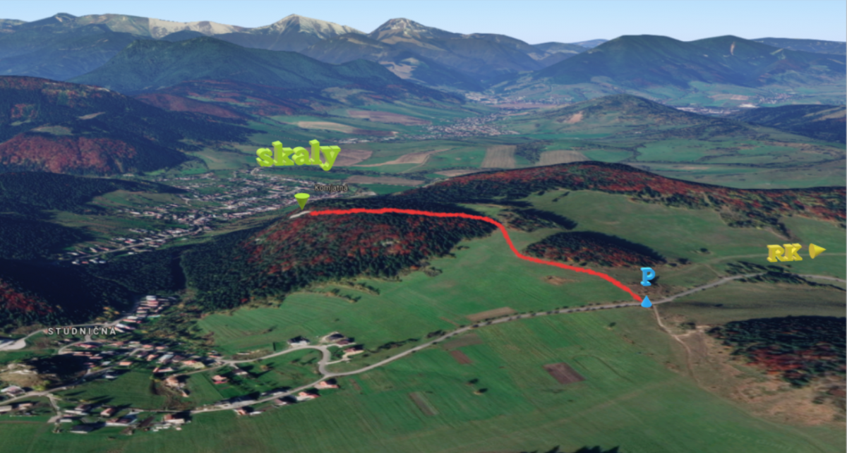
The newest climbing area in Liptov consisting of a 50-metre-high conglomerate rock. It towers over the boundary of the Studničná and Komjatná villages, in the municipality of Ružomberok. It hosts beautiful climbing routes for climbers of different levels and offers an opportunity to climb long routes. An amazing feature of conglomerate rock is that it has many holds, scales and notches, which is why the area is the top rock climbing destination in Liptov. The view from the top of the rock is one of the most beautiful in the region.
Climbing permitted: all year round
Info james.sk: List of climbing areas in Slovakia, restrictions, rocks wardens
No. of routes: 35
Difficulty: V – X- UIAA
Length of routes: 20 – 45! m
Approach
Approach: 15 min.
Take the road leading from Ružomberok towards Dolný Kubín. At Komjatná turn right and carry on for about 2 km up the hill. You will see Studničná – part of the Komjatná village – from there. Park the car on the hill, right next to the chapel that stands next to the road. Then take the field path towards Komjatná. Cross the meadow and walk the steep short hill that will lead you to the forest. Turn left to the forest and follow the footpath. It will take you 5 minutes to get to the top of the reef. There is a path on both sides of the reef leading down under the rocks.
Veľkonočná hrana, VIII
Description: 15 glue-in stainless steel bolts + abseil chain.
One of the best routes in Komjatná. It starts with a 10-metre long corner that leads to a rest shelf. It then continues with a rounded edge over which you will get to the final face. The route is airy and will test your endurance.
See www.shsjames.org for current restrictions.
The newest climbing area in Liptov consisting of a 50-metre-high conglomerate rock. It towers over the boundary of the Studničná and Komjatná villages, in the municipality of Ružomberok. It hosts beautiful climbing routes for climbers of different levels and offers an opportunity to climb long routes. An amazing feature of conglomerate rock is that it has many holds, scales and notches, which is why the area is the top rock climbing destination in Liptov. The view from the top of the rock is one of the most beautiful in the region.
Climbing permitted: all year round
Info james.sk: List of climbing areas in Slovakia, restrictions, rocks wardens
No. of routes: 35
Difficulty: V – X- UIAA
Length of routes: 20 – 45! m
Approach
Approach: 15 min.
Take the road leading from Ružomberok towards Dolný Kubín. At Komjatná turn right and carry on for about 2 km up the hill. You will see Studničná – part of the Komjatná village – from there. Park the car on the hill, right next to the chapel that stands next to the road. Then take the field path towards Komjatná. Cross the meadow and walk the steep short hill that will lead you to the forest. Turn left to the forest and follow the footpath. It will take you 5 minutes to get to the top of the reef. There is a path on both sides of the reef leading down under the rocks.
Televíkendová, V+
Description: 11 glue-in stainless steel bolts + abseil chain.
A nice route for getting acquainted with the area. It finishes with a comfortable stance from where you can climb the route called Zuzkina, which has the difficulty level of VI. Take a long enough rope! The route is named after the Televíkend TV show in which the route was climbed.
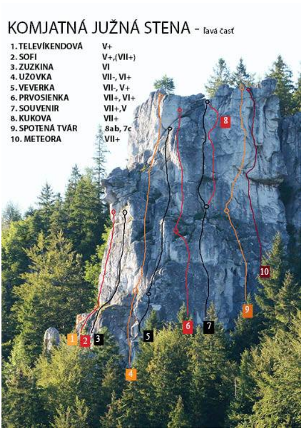
See www.shsjames.org for current restrictions.
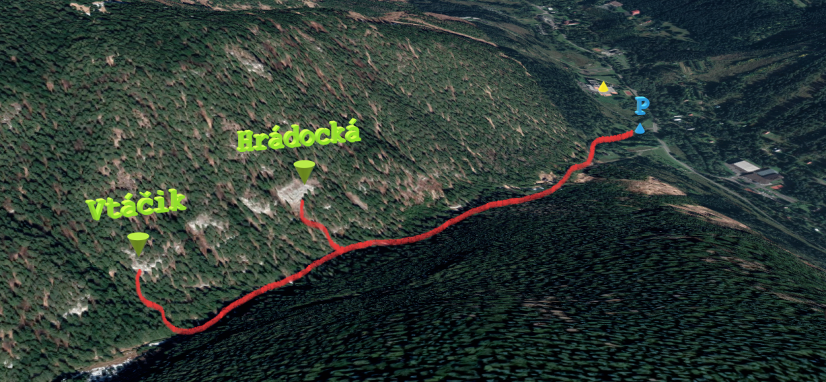
A nice quiet area hidden in the woods of the Biela dolinka behind the Liptovský Ján village. It comprises several limestone reefs that are divided into four main sectors. It is suitable for beginner as well as experienced climbers who favour technical routes. The big advantage is that climbing is allowed all year round and so you can spend nice time here on warm winter days.
The routes vary in difficulty, ranging from IV to IX+ UIAA, with most of them having the difficulty level of around VI and VII. The routes are technical and the longer ones are also strenuous, requiring a great deal of endurance.
Climbing permitted: 1. 8. – 31. 1., a od 1. 2. – 31. 7.
Info james.sk: List of climbing areas in Slovakia, restrictions, rocks wardens
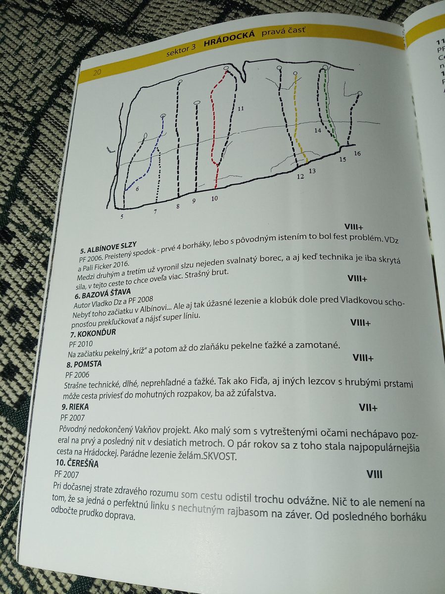
Sector: Hrádocká
No. of routes: 16
Difficulty: V – IX UIAA
Length of routes: 10 – 33! m
Approach
Approach: 15 min.
Take the Liptovský Ján exit from the D1 highway, drive through the village and into the Jánska valley. Pass the thermal swimming pool and the Strachanovka hotel and restaurant. Continue past the Bystrá hotel (on your right) and take the first right. Park your car in the parking lot next to a waterworks building and then walk the valley past the creek for about 10 minutes. At the point where the forest footpath crosses the creek keep to the right and walk the path uphill to the rocks (5 minutes).
Rieka, VII+
Description: 12 glue-in stainless steel bolts + abseil chain.
A beautiful long endurance route that will challenge your finger strength at the beginning and test your endurance at the end.
See www.shsjames.org for current restrictions.
A nice quiet area hidden in the woods of the Biela dolinka behind the Liptovský Ján village. It comprises several limestone reefs that are divided into four main sectors. It is suitable for beginner as well as experienced climbers who favour technical routes. The big advantage is that climbing is allowed all year round and so you can spend nice time here on warm winter days.
The routes vary in difficulty, ranging from IV to IX+ UIAA, with most of them having the difficulty level of around VI and VII. The routes are technical and the longer ones are also strenuous, requiring a great deal of endurance.
Climbing permitted: 1. 8. – 31. 1., a od 1. 2. – 31. 7.
Info james.sk: List of climbing areas in Slovakia, restrictions, rocks wardens
Sector: Vtáčik – City center
No. of routes: 21
Difficulty: IV – VII UIAA
Length of routes: 8 – 12 m
Approach
Approach: 15 min.
Take the Liptovský Ján exit from the D1 highway, drive through the village and into the Jánska valley. Pass the thermal swimming pool and the Strachanovka hotel and restaurant. Continue past the Bystrá hotel (on your right) and take the first right. Park your car in the parking lot next to a waterworks building and then walk the valley past the creek for about 10 minutes. At the point where the forest footpath crosses the creek keep to the right and walk the path uphill to the rocks (5 minutes).
Vtáčik – Prvá IV
Description: 5 glue-in stainless steel bolts + abseil chain.
Nice and easy route ideal for beginner climbers to make their first contact with the rock.
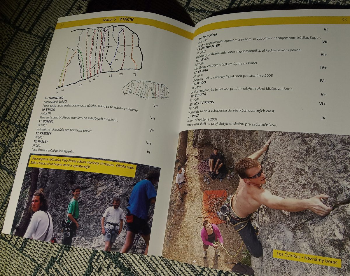
GPS súradnice Vtáčik: 49.02251, 19.65695
See www.shsjames.org for current restrictions.
In the ski centre Jasná, they have a long-standing interest in the possibilities of taking time off for an active recreation. The offer was also supplemented by routes for cross – country skiing lovers — a three-kilometre circle in the locality called Zadné vody.
The tracks will be prepared exclusively on natural snow. Due to their altitude above 1 200 meters above sea level, they foresee a relatively high guarantee of sufficient snow and the usability of prepared routes. The track shall be prepared by the centre’ s track modification vehicles (ratracks).
We recommend taking the cross-country routes and parking on the road under Tri vody (Three Waters) – opposite the Hotel Sorea Marmot.
Cross-country skiing routes are also suitable for families with children.
Try other circuits in the area of Zadné vody:
Sports circuit in the area Jasná Zadné vody
more information HERE
The Chalet conjunction
Route for access to circuits from the location called Otupné above the TMR chalets. At the beginning of the conjunction, it is possible to access the dismounting routes which are not too steep in their lower parts. An interesting information is from the winter of 2020, when ski slopes called Biela put, Luton Traver and the lower part of the ski slope, named Chaletova, were covered by cross -country trails during Lock down. It is these slopes that can serve as an access to the circuit for the cross – country skiers.
Download GPX file.
The project is implemented with the financial support of the Ministry of Transport and Construction of the Slovak Republic.
Winter closure: the ski mountaineering season lasts 15.12. – 15.4.
The best time for the trip: spring (March, April)
Equipment: depends on the conditions, ski crampons are recommended, crampons and ice axe – in case of icy conditions, avalanche equipment is necessary
Route description
Baranec is the dominant peak of the Žiarska valley and within the Western Tatras also one of the highest hills with a height of 2185 meters. A large part of the route is completed on foot, so it is necessary to have mastered the movement in crampons and the use of ice axe. Also, most of the route is oriented northwest, so there is almost no sun in this area during the winter months. It is therefore often possible to find powder snow here, even though in other parts of the valley it has long since been transformed by sunlight.
However, such shady and steep slopes can be very dangerous, especially in December and January, when the sun’s rays do not reach here, so snow stabilization process is not possible and unstable layers of snow can form. Therefore it is recommended to enjoy this route at the end of March, or at the beginning of April, when the snow in this area is already relatively stabilized and it is too hot on the other slopes. However, due to the inclination, it is always necessary to monitor the current conditions and the development of the avalanche situation.
Way up
The route starts at the mouth of Žiarska valley (Žiarská dolina), right at the parking lot. The valley has an elevation of about 400 meters in 5 kilometres distance, It is sometimes ridden by a snowmobile, or has a ski track already made by other ski tourers.The route passes smoothly around Žiarská chata, which is an ideal stop for refreshments before the ascents gets more demanding (and steeper).
From Žiarská chata, the ascent leads towards the former ski lift, to the right of the tourist trail. From the so-called an old ski lift route crosses a stream. In case of a heavy winter it can be frozen, but even during weaker winters it is not a problem to skip it. A suitable place for its crossing is in the middle of the old slope. It is often possible to follow the track of other ski mountaineers, or it is possible to use gps navigation and gpx coordinates, which are part of the article.
At the beginning, the slope still allows climbing on the skins, but then the couloir is already steep, and it is more advantageous to go on foot or on crampons with skis on a backpack. The entire ascent from the crossing the stream has an elevation gain of almost 800 meters, which can be challenging even for skilled ski mountaineers. The advantage of this steep ascent is that the ridge can be reached relatively quickly. The last part the ascent leads along the ridge to the very top. This part can be wind-blown up to the grass and rocks.
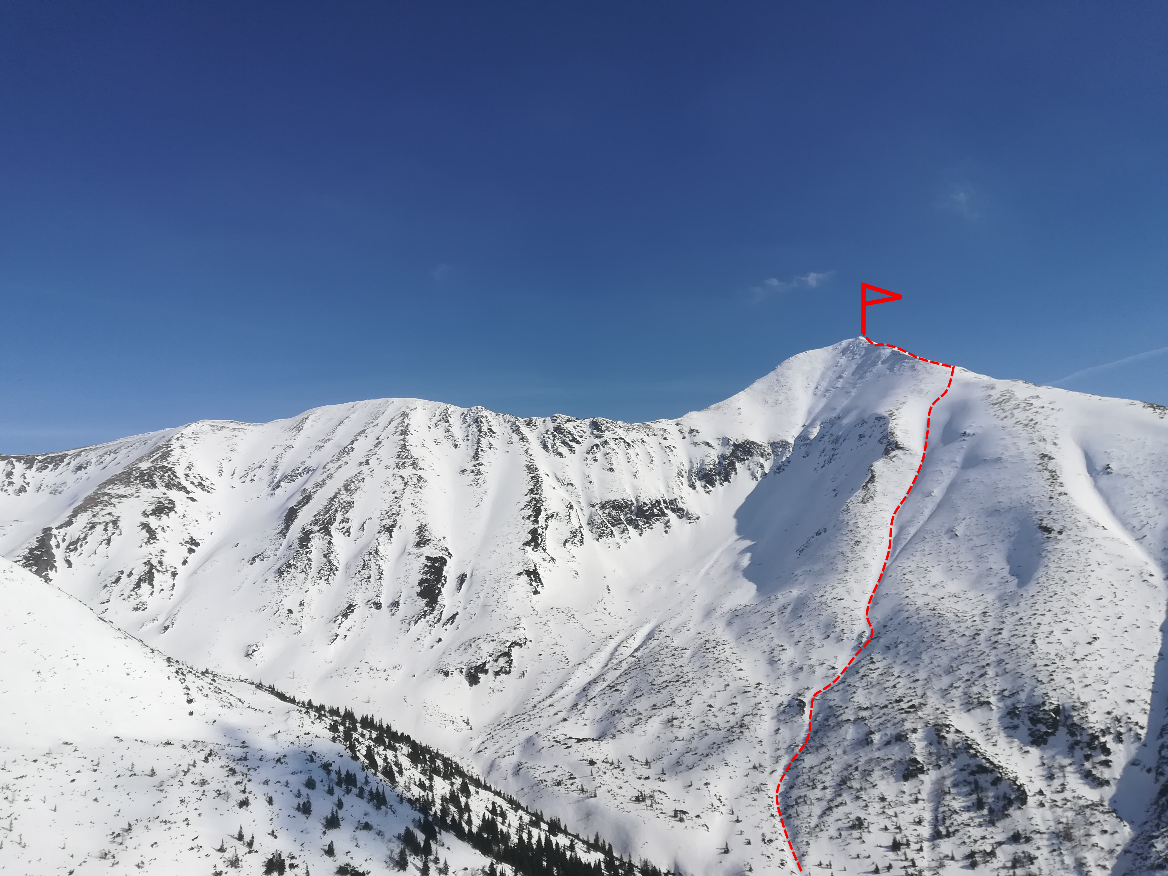
Way down
The descent has several variants. Directly from Baranec there are three main slopes: Hungarian, Spring and Central. The most difficult is the Central one, because during mild winters there is a small icefall in its middle. The other two are easier, but are only recommended for experienced and good skiers. Less experienced skiers can use the option of continuing along the ridge towards peak Smrek, or up to Žiarské sedlo (Žiarske Saddle).
From the ridge there are nice views all around and the descent from Žiarské sedlo should not be a problem even for slightly weaker skiers. However, it is very important to watch the conditions, because even here in the spring the snow can be very hard, it is often necessary to wait until the afternoon for the surface to finally soften and enjoy skiing.
Attractions on the route
Symbolic cemetery for the victims of the Western Tatras – the cemetery was created by the Mountain Rescue in the Western Tatras to the growing number of victims of mountain accidents over the last two decades and taking into account the efforts of survivors and friends to place memorial symbols in places of accidents.
Medvedia štôlňa – is the longest tunnel in the Massif of the Western Tatras and at the same time the only accessible old mining spot in Liptov. The underground spaces reveal the secrets of mining work, the methods of transporting mining material and the obstacles that miners encountered while working.
Availability and parking options
By bus: there is a stop in the valley, but the buses come only occasionally
By car: large-capacity, unguarded, paid parking lot with toilet, right at the beginning of the route
Refreshment options along the way
Žiarska chata – there is a hut’s kitchen and a cantine with a rich offer of drinks and meals. Please note that card payment is not possible.
Accommodation options along the way
Žiarska chata – we recommend booking accommodation in advance due to the popularity and availability of the hut. Weekends are often booked months in advance.
In the vicinity of the parking lot there are several other facilities that also offer restaurant and accommodation services – Hotel Spojár, Salaš Žiar, hut Kožiar, hut Třinec.
Author’s notes and tips
+
exposed, difficult downhill
thanks to the steep ascent quickly on the ridge
the snow stays here until late spring
–
avalanche risk in the winter
after the north-western winds, the couloirs lack snow
Winter closure: the ski mountaineering season lasts 15.12 – 30.4.
Best time for the trip: the whole season
Equipment: avalanche equipment
Route description
The aim of the route is Ďumbier, the highest peak of the Low Tatras. The trip can be extended by a visit to the M. R. Štefánik Hut (Chata M. R. Štefánika) in Sedlo pod Ďumbierom, which is located 400 meters lower, but then the way back would require to follow the same part of the trail with 400 meters of elevation gain. The descent can be skied in free terrain from Krúpova hoľa, less experienced skiers are advised to continue along the ridge to the nearby Chopok and continue down the ski resort slopes.
Way up
The starting point is the parking lot in Lúčky. The first part of the ascent leads along the “Turistická” ski slope, which is one of the least steep in the Jasná resort. The ascent route leads along it for about 2.5 km and 400 altitude meters. Later, it continues into the red marked trail at the lower station of the lift to Pekná vyhliadka. The route turns to the left into the forest and continues along the hiking trail slightly down the hill and then through the traverse towards the mouth of the Široká valley. This part of the route is mostly located in the forest and the first views appear at the mouth of the Široká valley.
The ascent continues up in Široká dolina and copies the summer green marked tourist trail to Krúpova hoľa. The slope of the ascent gradually increases. However, a slightly gentler ascent can be completed in the left part towards the Kráľov stôl and then along the ridge to Krúpova hoľa. The route continues to the main ridge of the Low Tatras and the red marked tourist trail. It is already close to peak Ďumbier – about a kilometer, with an ascent of about 120 meters.
A concrete pylon with a a large double door cross has been built on the top of Ďumbier. The peak also offers an extensive circular view of virtually all the mountains of central and northern Slovakia.
Way down
Directly from the top, return about a kilometer along the ridge and enjoy a descent from Krúpova hoľa, where the northwestern slope offers good skiing.
Less experienced skiers can continue along the ridge to Chopok and complete the descent on ski slopes. In case of lack of snow or in the spring, it is possible that ridge will miss snow and the skies would need to be carried in hands.
Attractions on the route
Educational trail Demänovská dolina – On the route Jasná – Tri vody – Luková – Široká dolina – Lúčky there are 9 information boards and benches for a pleasant rest. Natural and artistic elements along the route explain more about the dragon, which allegedly lived in the surrounding caves.
National Nature Reservation Ďumbier – spreads over the top of Ďumbier in the main ridge and on the northern slope at the end of the valleys. The protection is focused on the alpine landscape of rocky hills and gutters, knee timber stages and mountain coniferous forests with diverse fauna, flora and unique species.
Journey of the SNP Heroes – A red-marked tourist trail of European significance named in honor of the Slovak National Uprising, which is the dream of many tourists.
Availability and parking options
By bus: regular buses
By car: Lúčky parking lot
! Please note that the parking capacity may be full, especially during the high season from the early morning hours already
Refreshment and accommodation options
Several private cottages directly in Lúčky, hotels in Jasná
M. R. Štefánik Hut (Chata M. R. Štefánika) – open daily, all season, there is a hut’s kitchen available, as well as the possibility of accommodation.
Notes
+
infrastructure – hotels, parking lots, restaurants
possible transport by ski bus
long season due to the northern orientation
modified ski slope from the parking lot
views
–
ascent (and descent) on a narrow sidewalk in the middle of the route
full parking, traffic in high season
frequent strong wind on the ridge
Winter closure: the ski mountaineering season lasts 15.12 – 30.4.
Best time for the trip: all season with enough snow
Equipment: depends on the conditions, ski crampons are recommended, crampons – in case of icy conditions, avalanche equipment is necessary
Route description
The goal is the peak of Ďurková in the main ridge of the Low Tatras. The peak itself is not very striking, but it is sought after because of the views and good accessibility from the village of Magurka. Another attraction is the tourist shelter under Ďurková, which is located less than 100 meters below the ridge.
However, the descent from Magurka is not suitable for beginners, because it is located in open, free terrain.
Way up
The route starts directly in the village Magurka, where it is easy to park. It is located at an altitude of 1035 masl on the northern side of the Low Tatras. From the point of view of ski mountaineering such a location is very advantageous, because the snow stays here for a long time and at the same time it is close to the main ridge from here. The ascent to the ridge itself is quite steep, gain is almost 600 meters in less than 3 kilometers. It leads along the blue and then yellow trail marking to Zámostská hoľa (1625 masl).
The lower part stretches through the forest, which gradually thins. From about 1500 masl there are almost no trees left. From Zámostská hoľa there is only a slight ascent along the red trail marking to Ďurková. The ridge delights with beautiful views of the Great Fatra (Veľká Fatra) and the ridge of the Low Tatras (Nízke Tatry). It is possible to continue for another approximately 100 meters in the direction down south and enjoy refreshment in the shelter.
Way down
The first part of the descent leads along an unforested ridge on a slight slope. The descent then turns north and leads initially through a sparse, gradually dense forest back to the settlement.
The route itself is not threatened by avalanches that much, but the other slopes from Ďurková towards the Viedenska valley offer risk of avalanches.
Attractions on the route
Mining tradition – although the first reports of gold mining in this area date back as far as to around 1250, back then it was probably about panning for gold from the deposits of the Ľupčianka stream. The settlement of Magurka was founded as a mining settlement in the 14th century. Gold was mined and washed by hand, over time machines came. The mines themselves are located above Magurka on the northern slopes of Latiborská hoľa at an altitude of 1100 to 1400 masl.
Availability and parking options
By bus: no availability
By car: from Partizánská Lupča or from Liptovská Lužná. This is a poor quality road. The road to the Magurka settlement itself is difficult to cross in winter. With a lot of snow, it is good to be equipped with snow chains.
Refreshment and accommodation options
Hut Magurka, open daily, with accommodation and hut’s kitchen. Cottage Ďurková, open daily, with cantine and cottage’s kitchen – but has a significantly lower standard (sleeping on mattresses).
Notes and tips
+
the starting point (high)
quick ascent to the ridge
place of rare visits
–
poor quality access road
no bus connections
Winter closure: the ski mountaineering season lasts 15.12. – 15.4.
Best time for the trip: all season with enough snow , but the best in the spring
Equipment: depends on the conditions, ski crampons are recommended, crampons – in case of icy conditions, avalanche equipment is necessary
Route description
The goal is the peak between peaks Tri kopy and Baníkov in the main ridge of the Western Tatras. A grassy peak, which on the northern side is adjacent to the alpine ski area Zelená dolina (Zelená valley) on the Orava side of the Western Tatras. However, the route leads in free terrain, so it is not suitable for less experienced skiers or beginners (especially in the case of icy conditions).
Way up
The route starts at the mouth of Žiarska valley (Žiarská dolina), right at the parking lot. The valley has an elevation of about 400 meters in 5 kilometres distance, It is sometimes ridden by a snowmobile, or has a ski track already made by other ski tourers.The route passes smoothly around Žiarská chata, which is an ideal stop for refreshments before the ascents gets more demanding (and steeper).
The route passes smoothly around Žiarská chata, which is an ideal stop for refreshments in front of the more demanding (and steeper) part of the ascent. Above the cottage it is already free unpaved terrain, initially slight with a slope of up to 30°. The key place in terms of navigation is in the woods, about 500 meters away from the cottage. Here, the road divides in the direction to the left into the area of Veľké Závraty (also direction of Hrubá kopa peak), and in the direction to the right to Malé Závraty (Plačlivé and Žiarske sedlo).
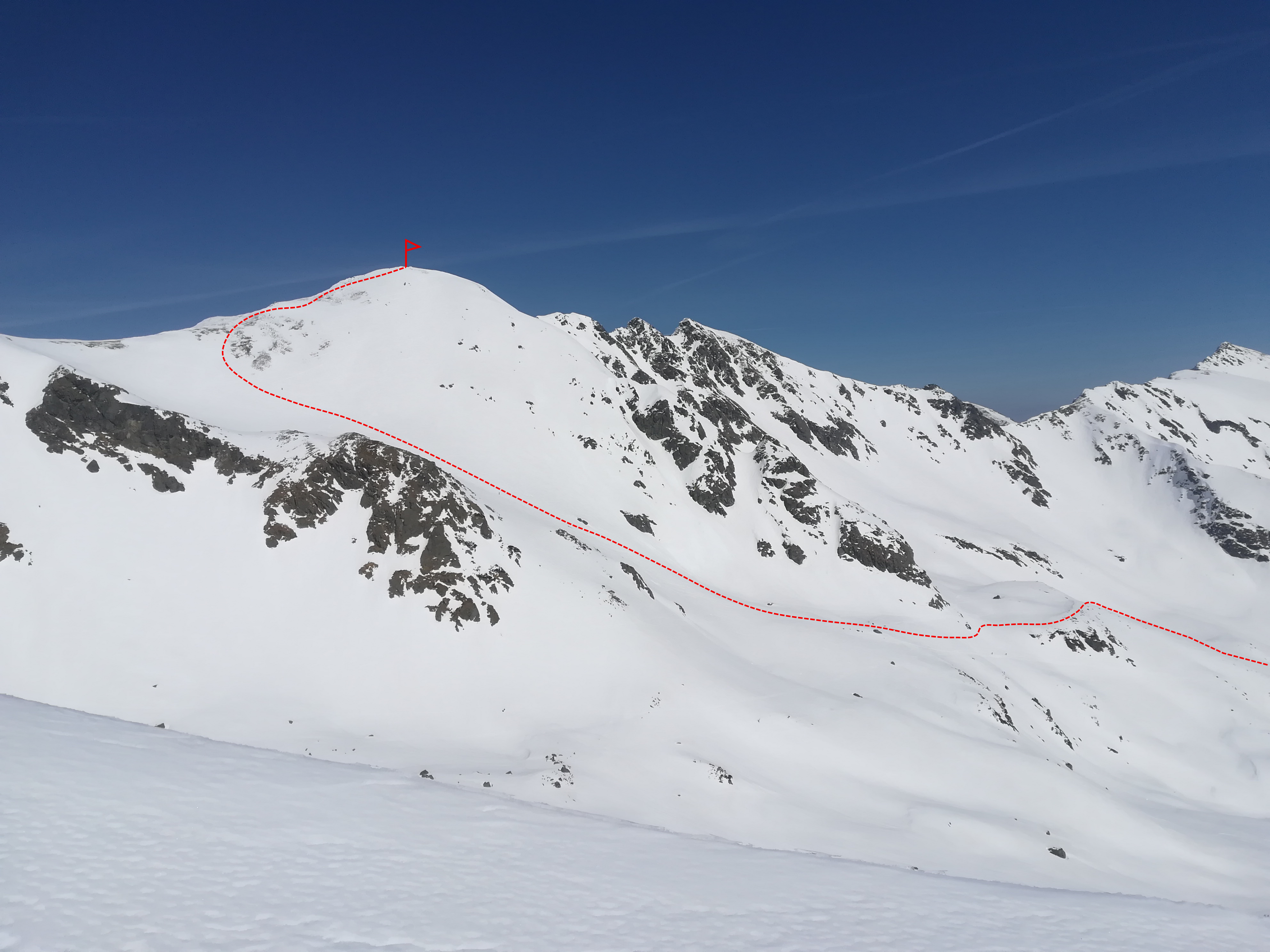
The mentioned crossroads is followed by a steep section between knee timber trees. This section is often slippery, hard, with bumps, and sometimes it is necessary to use ski crampons at this point. It is also narrow, and therefore it is necessary to pay attention to skiers had chosen to hike earlier and are already returning downwards.
The terrain will subside after about 500 meters and the route leads through the so-called Terrace. Just above the terrace there is the area, which gets threatened by avalanches often. The ascent leads to the left towards the meteorological station of the Avalanche Prevention Center. From there, the traverse continues even further to the left under the rock face. This place can also be dangerous in terms of avalanches, so be careful here. The Terrace continues towards Lúčné sedlo (Lúčne Saddle). If the conditions are bad it is possible to end the hike here, at an altitude of approximately 2050 masl.
From the Saddle it is only about 200 meters of elevation gain more to Hrubá kopa peak. The conditions are very diverse here, but often the ridge to the top is wind-blown up into ice or hard snow, so it is often necessary to use crampons, or to proceed on foot with skis on a backpack.
Way down
It leads almost identically to the ascent route. Descent, very pleasant, is almost entirely facing south, so excellent skiing is enjoyed in the spring. However, powder snow will not last very long in this area. Conditions can be complicated by wind, as frequent northwest winds sometimes create unpleasant snow slabs.
This peak is skied often. It is also possible to use the option to ski the couloir between Hrubá kopa and Tri kopy peaks (so-called Madajov couloir). However, it is significantly steeper and also significantly more dangerous in terms of avalanches.
Attractions on the route
Symbolic cemetery for the victims of the Western Tatras – the cemetery was created by the Mountain Rescue in the Western Tatras to the growing number of victims of mountain accidents over the last two decades and taking into account the efforts of survivors and friends to place memorial symbols in places of accidents.
Medvedia štôlňa tunnel – is the longest tunnel in the Massif of the Western Tatras and at the same time the only accessible old mining spot in Liptov. The underground spaces reveal the secrets of mining work, the methods of transporting mining material and the obstacles that miners encountered while working.
Availability and parking options
By bus: there is a stop in the valley, but the buses come only occasionally
By car: large-capacity, unguarded, paid parking lot with toilet, right at the beginning of the route
Refreshment options along the way
Žiarska chata – there is a hut’s kitchen and a cantine with a rich offer of drinks and meals. Please note that card payment is not possible.
Accommodation options along the way
Žiarska chata – we recommend booking accommodation in advance due to the popularity and availability of the hut. Weekends are often booked months in advance.
In the vicinity of the parking lot there are several other facilities that also offer restaurant and accommodation services – Hotel Spojár, Salaš Žiar, hut Kožiar, hut Třinec.
Notes and tips
+
long descent
views
infrastructure: parking, mountain hut
good snow conditions almost the whole season
–
long ascent
poor bus connections
High traffic (tourists)
Winter closure: the ski mountaineering season lasts 15.12 – 15.4.
Best time for the trip: all season with enough snow
Equipment: depends on the conditions, ski crampons are recommended, crampons – in case of icy conditions, avalanche equipment is necessary
Route description
Plačlivé, also called Plačlivý Roháč, is a significant peak in the main ridge of the Western Tatras. It is a distinctive pyramid that can be seen from afar. Together with Ostrý Roháč peak, they form an iconic panorama, thanks to which this part of the Western Tatras is also called Roháče. It attracts with good accessibility from Žiarské sedlo and an excellent view. The whole route is located in free alpine terrain, thus it is not suitable for beginner ski mountaineers. Although the route is not one of the most endangered by avalanches, it is nevertheless necessary to follow the knowledge of avalanche issues and carry mandatory avalanche equipment all the time. The whole way up can be completed, during almost the entire season, on ski mountaineering skins. Ski mountaineering crampons are only needed exceptionally, under very adverse conditions (eg icy snow surface).
Way up
The route starts at the mouth of Žiarska valley (Žiarská dolina), right at the parking lot. The valley has an elevation of about 400 meters in 5 kilometres distance, It is sometimes ridden by a snowmobile, or has a ski track already made by other ski tourers.The route passes smoothly around Žiarská chata, which is an ideal stop for refreshments before the ascents gets more demanding (and steeper).
Above the cottage there is free open terrain, initially slight with a slope of up to 30°. The ascent route copies the summer marked trail and alternates steeper sections with milder ones. Initially, the route leads through the forest and knee timber trees, which gradually thin. With ascending height meters, the views of the whole valley and especially of Baranec, the highest peak in the whole valley, open up. As if within reach is the goal of the ascent – the top of Plačlivô. The way up continues around the crossroads below Homôľka. On the left, the summer path leads to Smutné sedlo (Smutné Saddle), on the right, the route continues to Žiarské sedlo (Žiarske Saddle).
One more steep climb and there is Žiarske sedlo with a pleasant platform to rest before the last section leading to the top. The Saddle is 208 meters high from the top and about half an hour of steep hikes. During icy conditions, it is necessary to use ski crampons, or crampons and climbing axe. At the very top there is a compact view of the southern and northern side of the Western Tatras, with Liptov, Orava and Kriváň peak.
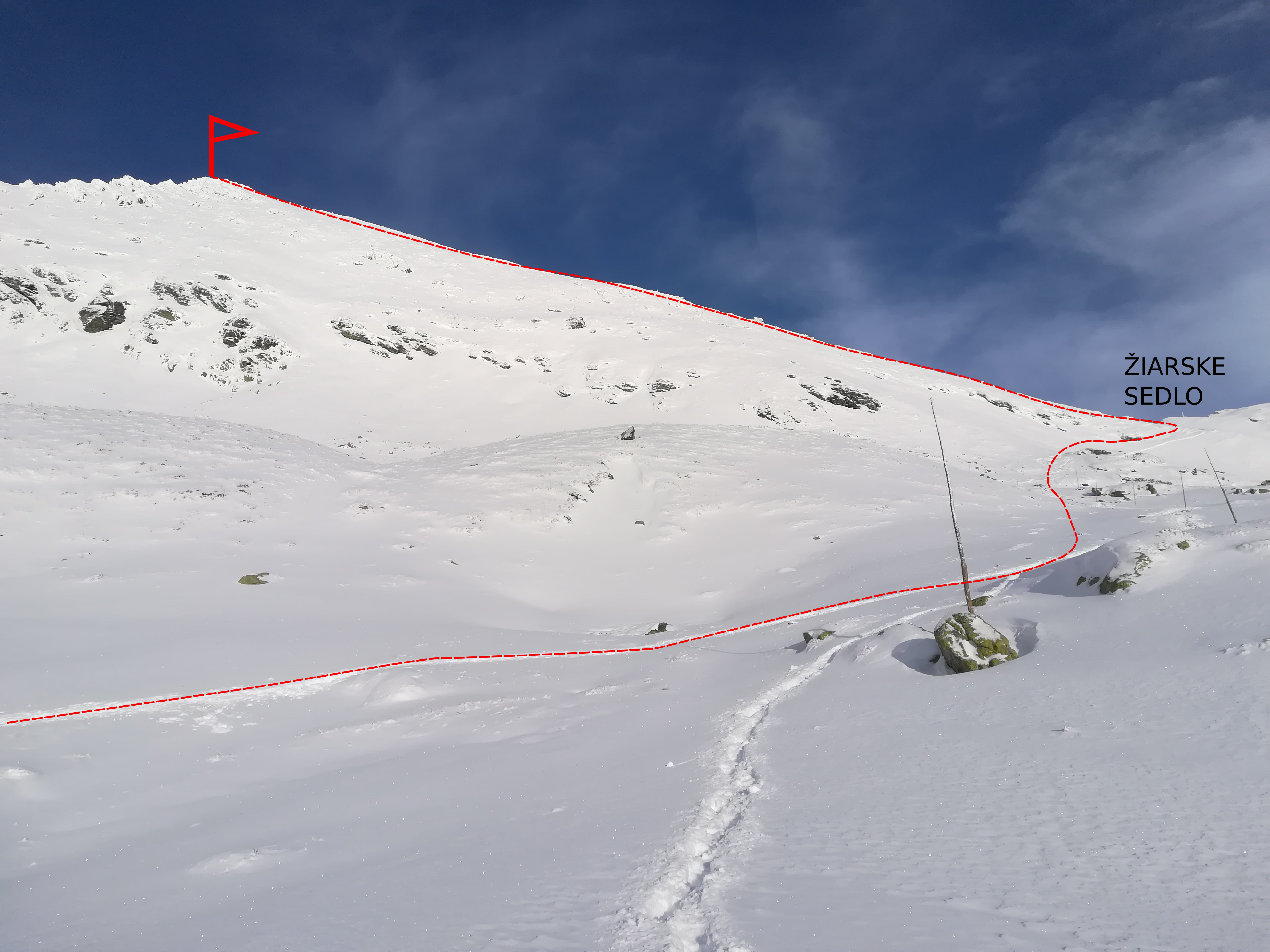
Way down
The slope is wide, with several descent routes interrupted by rocks. Beware of avalanche terrain, especially in the right part above the crossroads below Homôlka. The inclination is around 30 to 40° and there is less space for maneuvers in the upper part, but enough in the lower part. In milder winters, however, timber knee trees stick out out significantly in the lower part, so mind to be careful in this part, too.
Attractions on the route
Symbolic cemetery for the victims of the Western Tatras – the cemetery was created by the Mountain Rescue in the Western Tatras to the growing number of victims of mountain accidents over the last two decades and taking into account the efforts of survivors and friends to place memorial symbols in places of accidents.
Medvedia štôlňa tunnel – is the longest tunnel in the Massif of the Western Tatras and at the same time the only accessible old mining spot in Liptov. The underground spaces reveal the secrets of mining work, the methods of transporting mining material and the obstacles that miners encountered while working.
Availability and parking options
By bus: there is a stop in the valley, but the buses come only occasionally
By car: large-capacity, unguarded, paid parking lot with toilet, right at the beginning of the route
Refreshment options along the way
Žiarska chata – there is a hut’s kitchen and a cantine with a rich offer of drinks and meals. Please note that card payment is not possible.
Accommodation options along the way
Žiarska chata – we recommend booking accommodation in advance due to the popularity and availability of the hut. Weekends are often booked months in advance.
In the vicinity of the parking lot there are several other facilities that also offer restaurant and accommodation services – Hotel Spojár, Salaš Žiar, hut Kožiar, hut Třinec.
Notes and tips
+
full alpine hike
views of Liptov and Orava
infrastructure: parking, mountain hut
good snow conditions almost throughout the season
–
poor bus connections
the lower part of the route is richly visited by tourists and pedestrians (traffic)
Winter closure: the ski mountaineering season lasts 15.12 – 30.4.
Best time for the trip: January, February, March
Equipment: avalanche equipment
Route description
Although the Veľká Fatra is not one of our highest mountains and does not boast such a brilliant relief as the Tatras, it has its charm for ski mountaineers. The ridge of Veľká Fatra offers views of the Tatras, Fatra, and lower hills in the southern half of Slovakia.
Peak Ploská is a hill typical for Veľká Fatra. Its slopes are grassy, without trees. They are mild, but offer interesting skiing in sparse woods or on wide plains. Ploská is one of the highest peaks in Veľká Fatra. Ski mountaineering skins are sufficient.
The ridge usually tends to be wind-blown. On the Turčianská side, beware of dangerous avalanche slopes. As very steep slopes and exposed, rocky gutters are absent in this area, the hike is also suitable for weaker skiers.
Way up
From the car right on the tracks. A big disadvantage may be the fact that the ascent starts low – only 705 masl, so there is not much snow – especially in light winters, or at the beginning or end of the season.
The whole ascent has a relatively even slope and a decent elevation of 840 meters. The slope is, paradoxically, given the smallest name at the very top. The name Ploská perfectly describes its shape.
The top is a large platform and has enough space to change the skins and prepare for the descent. The hike can be extended, for example, to the Turčianska side by following the red trail marking at Chata pod Borišovom (Hut Chata pod Borišovom) or by a ridge on both sides – for example to Ostredok and Krížna, or Rakytov peaks.
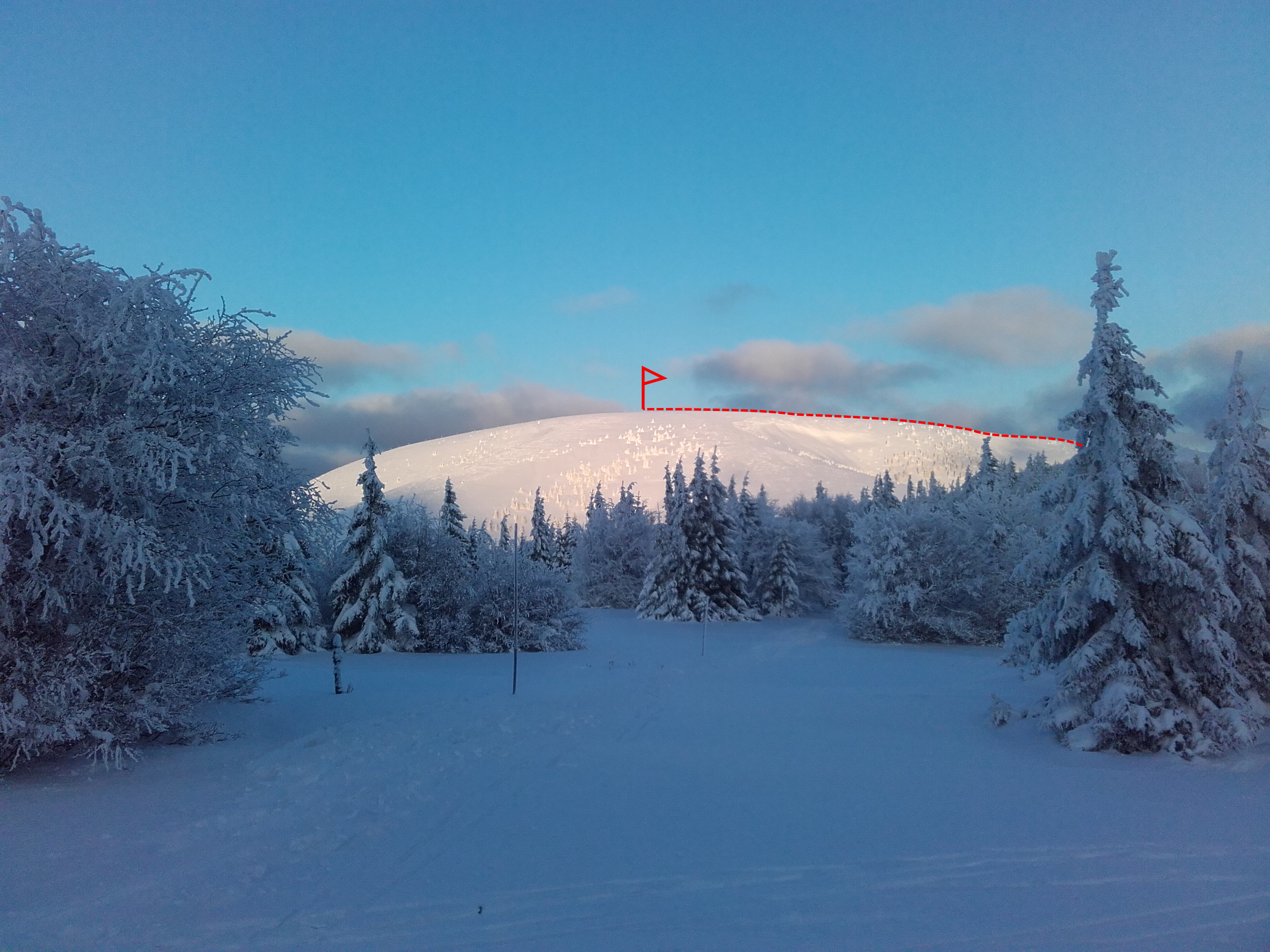
Way down
Copies the ascent route. At first it is characterized by a wide plain with a slight slope, gradually becoming steeper. Places where the forest is a bit denser can be tricky.
Attractions on the route
is located in the village of Liptovské Revúce-Záhorovo. It consists of two dominant and one secondary, smaller rock tower, which are connected by cable-stayed bridges. Beginning at an altitude of 800 masl visitors overcome parts of the route with difficulties of levels B, C to D, with the elevation of individual roads from 20 to 70 meters.
Those who do not dare to climb the adrenaline routes can get a view from the Two Towers via a traditional tourist educational trail.
Náučný chodník Čierny Kameň (The Čierny Kameň nature) is located in the central part of Liptovské Revúce. The 9.5 km long footpath (it should take approximately 5 hours for average tourist to complete it) with eight stops informs the visitor about the fauna and flora in the Great Fatra National Park, National Nature Reservation Čierny Kameň, but also about the local history during the Slovak National Uprising or mountain farming in this location. It is two-way round, available in summer and winter and winds along the route of red, green and yellow marked trails.
Accessibility and parking options
By bus: bus stop from Ružomberok
By car: directly from the village of Liptovské Revúce, part of Vyšná Revúca.
Refreshment and accommodation options
Chata pod Borišovom, private accommodation in the village of Liptovské Revúce
Author’s notes and tips
+
pleasant safe hike
suitable also for beginners/ less experienced
less busy compared to other routs
–
low altitude
need for suitable snow conditions
Winter closure: the ski mountaineering season lasts 15.12 – 30.4.
Best time for the trip: all season with enough snow
Equipment: avalanche equipment
Route description
The route is located on the northern side of the Low Tatras in the Demänovská dolina (Demänovská valley), which is a very popular tourist area, but just a short distance from the cable cars and tourists, this area enjoys reduced resort buzz. The Poľana Saddle is also such a case, and it is no less interesting that the other spots. It lies on the main ridge between Dereše and Poľana peaks. From the Saddle there are nice views not only of Chopok – Jasná, but also on both sides of the Low Tatras ridge (Horehronie and Liptov).
The trip is not recommended for beginners, it is necessary to be used to movement in alpine unimproved, free terrain. Crampons are rarely needed and it is usually possible to walk the entire route on ski mountaineering skins.
Way up
The route starts in Jasná. It is most often possible to go up on skins from the Marmot Hotel (formerly Šverma). The route leads through the valley of Zadná voda, copying the yellow trail marking mostly. A wide forest path gradually alternates sidewalk. It is steep in places and crosses the stream several times. The more snow, the easier the ascent.
About three kilometers later, the path leads to the narrow valley, the forest slowly turns sparse and the views of Dereše, Poľana Saddle and Bory appear. The route continues through a wide wold, which gets gradually steeper and continues directly into the Saddle. In the upper parts of the ascent, the inclination exceeds 30°. The direct track up at this point is already alternated by ski mountaineering turns, the so-called zigzags. The ridge and the section just below it are often wind-blown onto a hard surface, so in the case of bad conditions it is necessary to use crampons. In terms of avalanches, the last section is the most dangerous, because it is the steepest. The summit is a large platform, suitable for walking, but it is often windy here.
Should you be interested to continue, the route can be extended towards Dereše and Chopok peaks. More experienced skiers can then try the steep slopes of the Derešský kotol and return to the starting point of the route through Otupné. Those less experienced can continue along the ridge to Chopok and use the piste for downhill.
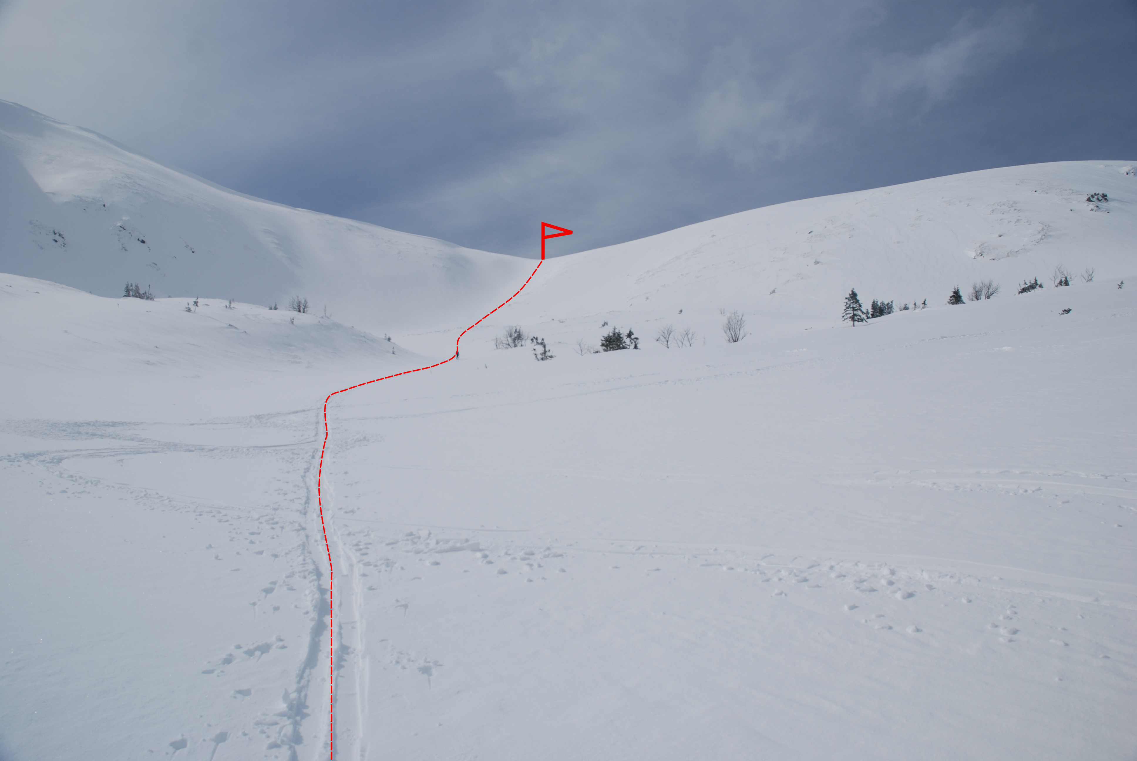
Way down
Leads along an identical route, the first section the steepest is, but it is a wide slope that invites to enjoy long ski curves. At the descent, the most critical section is the knee timber zone and the entrance to the forest, where there is little room for maneuvers and it also can get bumpy sometimes. Spots to cross a stream can also be dangerous.
In the case of powder conditions, skiing among the trees is great. The same applies to the ascent, the more snow, the easier the descent. The end is just a descent along a forest road.
Attractions on the route
Educational trail Demänovská dolina – On the route Jasná – Tri vody – Luková – Široká dolina – Lúčky – there are 9 information boards and benches for pleasant rest. Natural and artistic elements along the route explain more about the dragon, which allegedly lived in the surrounding caves.
Availability and parking options
By bus: Grand Hotel stop
By car: Free parking right at the starting point of the route in front of the hotel Liptov, Marmot, Mikulášska chata, or along the road.
! Please note that the parking capacity may be full, especially during the high season in the morning already
Refreshment and accommodation options
Endless, the nearest are the hotel Liptov, Grand, Marmot, hut Jasná, Mikulášska chata (Mikulášska hut), Happy end….
Notes and tips
+
Good infrastructure – hotels, parking lots, restaurants
transport also possible by ski bus
long season / northern orientation
despite the proximity of the ski resort, there are not many tourists on the route itself
–
ascent (and descent) on a narrow sidewalk in the middle of the route
full parking, traffic during high season
Winter closure: the ski mountaineering season lasts 15.12 – 15.4.
Best time for the trip: all season with enough snow
Equipment: depends on the conditions, ski crampons are recommended, crampons – in case of icy conditions, avalanche equipment is necessary
Route description
The goal is a distinctive saddle between peaks Tri kopy and Plačlivô on the main ridge of the Western Tatras. The Saddle connects the closed Smutná dolina (Smutná valley) in the winter with the Žiarská dolina (Žiarská valley). It is one of the most classic tours in the Western Tatras. However, it leads in rugged open terrain, so it is not suitable for less experienced skiers or beginners (especially in the case of icy conditions).
Way up
The whole way up can be completed, during almost the entire season, on ski mountaineering skins. Ski mountaineering crampons are only needed exceptionally, under very adverse conditions (eg icy snow surface).
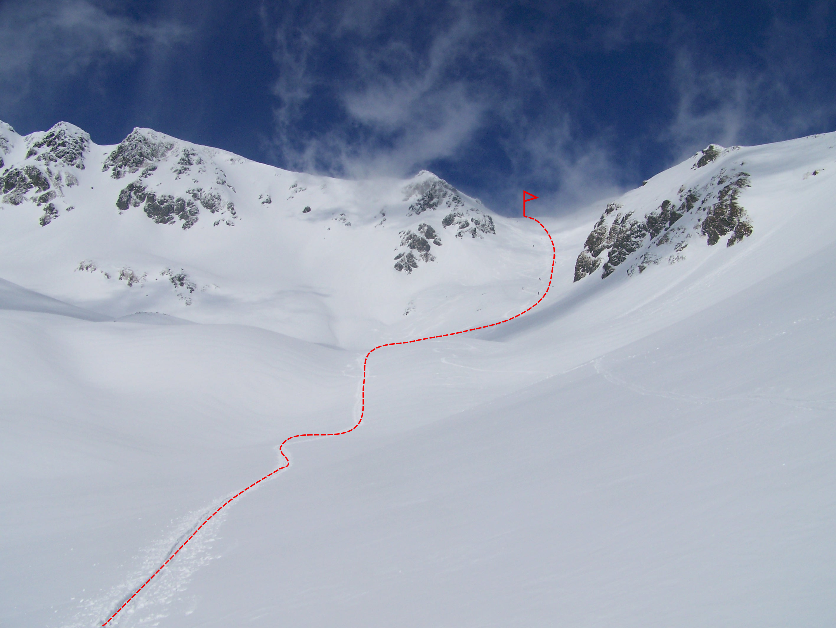
The route starts at the mouth of Žiarska valley (Žiarská dolina), right at the parking lot. The valley has an elevation of about 400 meters in 5 kilometres distance, It is sometimes ridden by a snowmobile, or has a ski track already made by other ski tourers.The route passes smoothly around Žiarská chata, which is an ideal stop for refreshments before the ascents gets more demanding (and steeper). Above the cottage there is already free terrain, initially slight with a slope of up to 30 °. The key place in terms of navigation is in the woods, about 500 meters away from the cottage. Here, the road divides in the direction to the left into the area of Veľké Závraty, where there is also Smutné sedlo, and in the direction to the right to Malé Závraty (Plačlivé and Žiarske sedlo).
! It is important to keep in mind that the winter road does not copy the summer route to Smutné sedlo. The mentioned crossroads is followed by a steep section between low trees and knee timber. This section is often slippery, hard, with bumps, and sometimes it is necessary to use ski crampons at this point. It is also narrow, and therefore it is necessary to pay attention to skiers who had chosen to start earlier and are already returning downwards.
The terrain subsided after about another 500 meters and the route leads through the so-called Terrace below the Smutné Saddle itself. From this place there is already a very good view of the whole of Velké Závraty, Baníkov, Tri kopy and the end point of the route – Smutné sedlo. Just above the Terrace there is an area challenged by avalanches begins. The right side, where the steep slopes of Prostredný Grúň are located, is dangerous, so one needs to be careful there.
The ascent towards the Saddle gradually becomes steeper, so-called “zigzags” (ski mountaineering turns) come to use. The Saddle itself is a pleasant plain with a beautiful view in the north with the massif of Plačlivý and Ostrý Roháč peaks in the south to Liptovská kotlina (Liptovská basin) and Baranec peak.
Way down
It leads almost identically to the ascent route. The Smutné Saddle is often skied. The central slope can sometimes be ridden by skiers and thus bumpy, otherwise, it is a wide gutter with a pleasant slope. In the upper part it is narrower, gradually expanding, reaching an inclination of more than 35°. Paradoxically, the most difficult section of the descent is in the knee timber zone, below the so-called the Terrace, because the descents from the surrounding hills converge and the space between the knee timber trees is quite narrow. Then, only the former ski slope follows back to Žiarska chata, which is an ideal place for refreshments after the hike. In case of sunny weather in the spring, the terrace on the south side of the cottage is a great place to relax, recharge your batteries and draw energy from the sun. From the hut to the parking lot, it is already a pleasant descent along the summer road.
Attractions on the route
Symbolic cemetery for the victims of the Western Tatras – the cemetery was created by the Mountain Rescue in the Western Tatras to the growing number of victims of mountain accidents over the last two decades and taking into account the efforts of survivors and friends to place memorial symbols in places of accidents.
Medvedia štôlňa tunnel – is the longest tunnel in the Massif of the Western Tatras and at the same time the only accessible old mining spot in Liptov. The underground spaces reveal the secrets of mining work, the methods of transporting mining material and the obstacles that miners encountered while working.
Availability and parking options
By bus: there is a stop in the valley, but the buses come only occasionally
By car: large-capacity, unguarded, paid parking lot with toilet, right at the beginning of the route
Refreshment options along the way
Žiarska chata – there is a hut’s kitchen and a cantine with a rich offer of drinks and meals. Please note that card payment is not possible.
Accommodation options along the way
Žiarska chata – we recommend booking accommodation in advance due to the popularity and availability of the hut. Weekends are often booked months in advance.
In the vicinity of the parking lot there are several other facilities that also offer restaurant and accommodation services – Hotel Spojár, Salaš Žiar, hut Kožiar, hut Třinec.
Notes and tips
+
change from a valley to alpine terrain in a short time
views
infrastructure: parking, hut
good snow conditions during almost the whole season
–
rare bus connections
high traffic
Closure: open all year
Best time for the trip: all season with enough snow
Equipment needed: avalanche equipment
Route description
The goal is the only mountain hut on the southern side of the Western Tatras, which is open every day, all year round. This route is popularly used by the very beginners, not that experienced skiers, whole families, or as a short hike in the mountains. It can also be completed with children, or as the first trip for people who are new to ski touring/ski mountaineering. Recently, it has become widely popular to visit the hut in the evening/dark, in the light of the headlight only. In December and January, when the days are short, this offers an excellent opportunity to enjoy sports. The charm has an evening ascent, especially in clear weather or heavy snow. The hut is open until 10.00 pm. The advantage of its location is the fact that it is not exposed to avalanches like other routes. However, the avalanche situation should not be underestimated even here either. In case of great avalanche danger, both the valley and the hut are closed.
Way up
The whole trip can be completed, for almost the entire season, on ski mountaneering skins, no other equipment is needed. The advantage of this trip is also the fact that it is not necessary to be in great shape or have great technical skills.
The trip starts at the mouth of Žiarska valley (Žiarská dolina), right at the parking lot. The whole route can be described as a slight climb. It is sometimes ridden by a snowmobile, or has a ski track already made by other ski tourers. The valley has an elevation of about 400 meters in 5 kilometres. Žiarska chata – a mountain hut is an ideal stop for refreshments. In case of nice weather in the spring, the terrace on the south side of the hut is a great place to relax, recharge your batteries and get that needed energy from the sun.
Way down
From the hut back to the parking lot, it is a pleasant descent on what what normally, when there is no snow, functions as a road. If the snow is wet, it is necessary to use skating style while skiing.
Attractions on the route
Symbolic cemetery for the victims of the Western Tatras – the cemetery was created by the Mountain Rescue in the Western Tatras to the growing number of victims of mountain accidents over the last two decades and taking into account the efforts of survivors and friends to place memorial symbols in places of accidents.
Medvedia štôlňa tunnel – is the longest tunnel in the Massif of the Western Tatras and at the same time the only accessible old mining spot in Liptov. The underground spaces reveal the secrets of mining work, the methods of transporting mining material and the obstacles that miners encountered while working.
Availability and parking options
By bus: there is a stop in the valley, but the buses come only occasionally
By car: large-capacity, unguarded, paid parking lot with toilet, right at the beginning of the route
Refreshment options along the way
Žiarska chata – there is a hut’s kitchen and a cantine with a rich offer of drinks and meals. Please note that card payment is not possible.
Accommodation options along the way
Žiarska chata – we recommend booking accommodation in advance due to the popularity and availability of the hut. Weekends are often booked months in advance.
In the vicinity of the parking lot there are several other facilities that also offer restaurant and accommodation services – Hotel Spojár, Salaš Žiar, hut Kožiar, hut Třinec.
Notes and tips
It should be taken into account that especially on weekends, this place is a popular destination for local and foreign tourists, either as the end point of their walk or a place where they stop during a longer hike to the surrounding peaks.
+
maintained route (road)
views
infrastructure: parking, hut
good snow conditions for almost the whole season
–
poor bus connections
high traffic
dogs not allowed
Winter closure of the trail: ski mountaineering season lasts 15.12. – 15.4.
Best time for the trip: all season with enough snow
Equipment: avalanche equipment
Route description
The goal is peak Babky (1566 masl), which is not one of the highest peaks, but because it is extended beyond the main ridge, it offers views of the Liptov basin (Liptovská kotlina), the Low Tatras (Nízke Tatry), the Choč Mountains (Chočské vrchy) and the Parichvost valley (dolina Parichvost) to the east. The slopes of Babky are grassy, with a sparse forest, which is ideal for skiing. The big advantage is that the route is not significantly endangered by avalanches. It can be safely completed even when conditions are not ideal, for example in the case of increased avalanche danger (3rd degree out of 5).
Way up
The surroundings of Babky and Červenec are a popular location for ski mountaineers/ski tourers. The ski track is almost always made here by others. The ascent starts at the parking place in the area of Bobrovecká Vápenica. The parking lot is located relatively low, at an altitude of about 750 masl. During light winters or at the beginning of the season, due to the lack of snow, it is not always possible to get on the tracks right from the parking lot. If there is enough snow, the whole trip can be completed on skins only, crampons are not needed.
The first part of the ascent leads through a meadow and after about 500 meters the forest continues. The beginning of the forest part is steep, but gradually the route joins the trail, along which the ascent gets more pleasant.
After about two kilometers, a resting place appears, as well as a crossroads. The left part goes in the direction of Babky, on the right the forest road continues to Chata na Červenci. From the rest stop on, the route to Babky copies the summer hiking trail. This is the most problematic part of the ascent as slope of the trail increases and the trees allow only bit of narrow space.
The views appear at the final part, which is already above the forest zone. The track often leads in the left part, because it is windy on the ridge and low trees offer a pleasant lee. The mountain top of is often wind-blown, but provides plenty of space. In case of lack of time or energy, it is possible to end the trip here and ski along the ascent route or through woods and glades back to the car. In good snow conditions, especially in powder, it can be great skiing.
However, the route continues in the direction of Chata pod Náružím (Červenec). After a short descent on the skins along the ridge, there is one more hill to pass – Malá Kopa – the peak standing directly above the cottage. It is necessary to change the skins here.
Way down
Leads from Malá kopa through a sparse knee timber trees directly to the hut (Chata pod Náružím). The inclination exceeds 30°. It is not long, but skiing is enjoyable, especially when there is enough snow and increased avalanche danger elsewhere. A pleasant part of the trip is to stop and refresh at the hut. From the hut itself, there is only a simple descent along the forest road back to the car. The descents are not very demanding and most of the season should be managed even by a less experienced skier.
Attractions on the route
Partisan bunker from the period of World War II – located roughly in the middle of the ascent along the forest road on the right. It is a rocky overhang, in which in the winter of 1945 eight men from Bobrovec survived for several weeks during World War II.
National nature reservation Sokol – Mních – there are rare species of plants and animals tied to the rocky relief and limestone subsoil.
Amateur ski race Cena Červenca – held on the first weekend of March (Saturday) since 1970. The start is at the Veľká kopa and the finish at the hut. This event has not only a sports but also a social dimension with an excellent atmosphere of a local race.
Availability and parking options
By bus: Jalovec bus stop
By car: free parking right at the starting point of the route, 3rd class road leads here, poorly maintained, with possibility of snowdrifts
Refreshment and accommodation options
Chata pod Náružím (Červenec hut) – the hut‘s kitchen does not work, services are limited to a tiny cafeteria with drinks and snacks.
The hut offers accommodation in a lower standard without electricity or shower. It is advisable to inform about the reservation in advance. Please note that card payment is not possible. The hut is open on all weekends and holidays.
In the vicinity of the parking lot there are several facilities that also offer restaurant and accommodation services – Hotel Mních, or a rich offer of private accommodation in the village Bobrovec, or the surrounding villages.
Notes and tips
+
views
easy and safe route
infrastructure (parking, hut)
–
high traffic
lower altitude – shorter season, weaker winters offer possibility of lack of snow
Detailed route description:
The cosy cottage in the Great Fatra is situated between the peaks of Ploská and Borišovo. The very well-equipped cottage with year-round operation and a wide selection of refreshments has a capacity of more than 20 people. The cottage is located at the crossroad of several trails. It is accessible from the valley of Ľubochnianska Dolina, from Liptovská Revúca, but also when passing through the Great Fatra artery or the ridges. If taking a hike from Liptovské Revúce you can start from Vyšná Revúca or Stredná Revúca. The way back can also lead along another trail through Močidlo leading you back to Liptovské Revúce.
We recommend all visitors that they take a climb to the peak Borišov (1509 MASL) along the yellow trail – in case of good weather they can enjoy stunning views of the Great Fatra´s large part and also of the basin of Turčianska Kotlina.
Availability and parking:
Parking is available in the village of Liptovské Revúce. There is also public transport circulating to the village from Ružomberok. The bus stop is located right at the starting point.
Accommodation and catering options:
Beverages and food are available in the village and cottage Chata pod Borišovom. When booking, please send a text message. The cottage manager will certainly respond to your inquiry.
Detailed route description:
Mountain Hotel Smrekovica is the most significant stop on a tourist trail leading from the Liptov (region) part of the Great Fatra ridge. It is situated between the observation peaks Skalná Alpa and Malá Smrekovica. The cottage can be reached from several routes. The most used is an asphalt road through Vyšné Matejkovo (along the blue trail) from the site Podsuchá, which lies on the main road Donovaly-Ružomberok. The route is suitable for both pedestrians and cyclists and it is also suitable for cars.
Smrekovica, however, is of great importance for tourists passing through the ridge of the Great Fatra, mainly because of its strategic location. They will find a great shelter here to recharge energy so important to conquer the Great Fatra ridge.
Availability and parking:
Parking is free of charge. There is also public transport running to the location. The stop is found directly in Podsuchá, near the Bodega roadhouse.
Accommodation and catering options:
Beverages and food are available at the beginning of the trail in Podsuchá and then in the Mountain Hotel Smrekovica cottage.
Detailed route description:
Májekova Chata is a long-standing star of the Malinô Brdo ski resort. The cottage is located in the beautiful surroundings of the Veľká Fatra (Great Fatra) mountain range and has been operating continuously since its establishment in 1968. It provides cosy accommodation for 42 people, food services in its own restaurant and other services including sports equipment rental or a mountain guide. The cottage benefits from its excellent location, which is appreciated by visitors, especially in the winter season.
Májekova Chata can be reached following a hike from Hrabovo or using a cable car from Hrabovo to Malinô Brdo. The cable car also operates in summer.
Availability and parking:
Parking in Hrabovo is free of charge. Public transport runs to the location and a ski bus is also available in the high season.
Accommodation and catering options:
Beverages and food are available directly at the Májekova Chata cottage.
To access the cross-country trails, you need to get behind an agricultural cooperative. After turning right behind the open-air museum of the Liptov village in Pribylina, you will cross the bridge and after exiting the hill you will turn left at the first possible turn. You will park the car in the free space.
The project is implemented with the financial support of the Ministry of Transport and Construction of the Slovak Republic.