There is a hut offering traditional Slovak cuisine in the valley, and you can find several food facilities also in the ski resort.


The area of the village Smrečany – the valley Žiarska dolina traditionally offers interesting conditions for cross-country skiers. The only condition is sufficient snow cover. At the beginning of winter, the local Physical Education Team called Družba Smrečany – Žiar will modify the tracks for classical style in cooperation with the municipalities and volunteers. They modify the tracks with the scooter, and later, in better conditions, with a snow tracked vehicle (snow groomer). You can donate some money for the maintenance of the trails on the account number displayed on the route starting information boards.
An interesting feature is the possibility to continue to the cottage Žiarská chata. It is not a cross-country skiing route in the right sense of the word, as it is also used by pedestrians and ski mountaineers. An even more interesting, but rarer route, is the possible connection of the routes to the World War II memorial Háj in the town Liptovský Mikuláš with the valley Žiarská dolina. Unfortunately, due to weaker winters, this connection has not been possible for a long time. If it is possible to modify the track, it will be a real ski magistrale.
The ideal starting point for cross-country skiing tracks is the parking lot at the turn of the bus at the end of the village Žiar on the left side. Parking is free. The route will take you to the meadows under the Tatra Magistrale with a nice view of the Western Tatras. In the centre of the meadow there is a well – Acidic mineral Water, but its yield has decreased so much that you will probably not be able to drink from it. You can refresh yourself in the buffet near the ski resort, or in the facilities at the beginning of the valley Žiarská dolina.
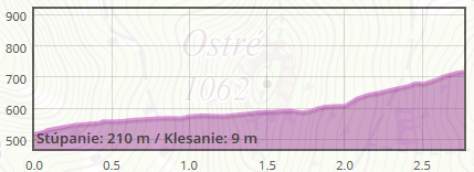
The circuit is lightweight at its bottom. The upper part immediately below the Magistrale is profiled by alternating short but steep hills. Performance cross-country skiers can enjoy the track. You can avoid these hard sections without any problems and the route can be shortened below the first hill.

The project is implemented with the financial support of the Ministry of Transport and Construction of the Slovak Republic.
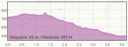
The legendary route, along the front line from the 2nd World War, is a rarity that occurs rarely. It runs mostly through the ridge, which tends to be blown out of the snow. Therefore the connection of the routes on Háj Nicovô with the valley Žiarska dolina quite rare. If it is possible to modify the track, it is a real ski resort. It is relatively light track, but you must be careful when skiing down over the agricultural yard in the village Žiar.
The best place from the start of the cross-country skiing route is a large free parking lot at the military monument Haj – Nicovô. It is near the town Liptovský Mikuláš. Good marking from the town centre of Liptovský Mikuláš will lead you here. From the parking lot, you will head back a few meters along the asphalt road you came from. You come to the cycling column with the name Turning to Haj located at the crossroad. Here you will turn onto the road, which is marked with no entry for motor vehicles. If there is enough snow, you can already put on cross-country skis here and then you are already following the route. On the right side you will pass the agriculture cooperative in the village Smrečany. You can get to the village Žiar and ski resort called Dolinky through the fields.
The project is implemented with the financial support of the Ministry of Transport and Construction of the Slovak Republic.
Cross-country ski trail in this village, known for its thermal springs, starts at a cycling crossroads near the Hotel SOREA Maj. It is possible to park in front of the hotel free of charge. The route does not have a clearly defined line. In case of good conditions, it usually leads to a field road leading to the village Závažná Poruba and back. It gradually copies the meadows along the hill Hrádok above the agricultural cooperative company.
The circuit is approximately 3-4 kilometres long. The track offers magnificent views of the mountain Kriváň. Its orientation promises sun-drenched tracks, especially in the morning. After good cross-country skiing, it would be a shame not to take advantage of thermal springs possibility for bathing. The thermal springs are in the near area. Modification of this route is provided by the municipality Liptovský Ján.
The project is implemented with the financial support of the Ministry of Transport and Construction of the Slovak Republic.
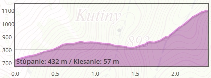
Cross – country skiing tracks begin in the area of Matej Staron physical movement center above the village Závažná Poruba. You can park your car for free in the parking lot below the Opalisko ski resort about 150 meters near the entry to the track. The track has a profile of racetracks, but it is also suitable for intermediate advanced skiers. The downhill is always followed by the counter-slope to reduce speed or at least a flat surface to slow down.
A large 5 km circuit will take you along the enclosure Brestová with venison to the meadows with a beautiful view of the Liptov region, also called Bánove lazy /hamlet/. This circuit rotates in many places, creating the possibility of shortening the route almost at any time. On the tracks, you can also find local signs, which make the navigation easier. In the further past, the tracks were modified up to the ski resort Iľanovo (Nezabudka cottage), but due to the denser vegetation, the passage of cross country skiing track technology is more complicated. However, they create a nice option for backcountry skiing enthusiasts out of the modified tracks.
The tracks in Závažná Poruba are modified and well-kept by the enthusiasts from the local Cross – country Skiing Club named Opalisko with the support of the municipality. In the future, they also plan to make an asphalt track for roller ski training, which will also simplify the track modification in the winter season with a low layer of snow cover.
The project is implemented with the financial support of the Ministry of Transport and Construction of the Slovak Republic.
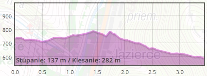
This almost 5km long route is suitable for medium skilled cross-country skiers. You can start the route in the valley Hrabovská dolina, where it is possible to park your car at the ski resort Ski & bike park Malinô Brdo and continue through the forest to the valley Čutkovská dolina, in which you will see beautiful huts Koliba Richtarka and Koliba u dobrého pastiera. You can refresh yourself here. Then you can return along the same route as you arrived, or go further through the valley, following the educational trail Known-Unknown valley Čutkovská dolina.
The project is implemented with the financial support of the Ministry of Transport and Construction of the Slovak Republic.
This circuit is often used by cross-country skiers. It has the length of about 1.5 km, from ski center Hrabovo to Malinô Brdo. You can also use the forest road under the cable car with the exit to Suché Hrabovo. From Suché Hrabovo you can continue towards the UNESCO monument the village Vlkolínec or by the “royal” road towards Smrekovica massif. This alternative is especially suitable for more skilled skiers and offers beautiful views from the Big Fatra main ridge of the surrounding mountains.
The project is implemented with the financial support of the Ministry of Transport and Construction of the Slovak Republic.
The cross-country skiing route is located directly in the ski resort Ski&Bike Park Malinô Brdo. The circuit is located below the cable car station in the central part of the resort. To get there, you need to take the cable car and ski a few meters down or walk to the Aprés ski bar. Below the bar you will see a circuit for cross-country skiing. The track is relatively fast and it is not suitable for the beginners. More advanced cross-country skiers, especially lovers of the skating style, will find something to enjoy. The higher position of the tracks and orientation in the shadow of the northern slope guarantees snow cover for most of the wintertime.
In addition to the described circuit, the resort also has a sporadically modified circuit in the meadows Vlkolínske lúky, but this is not the rule. It is advisable to combine a visit to this locality with the ascent through so-called “Bear Road” from ski resort Hrabovo with a continuation to the tracks near the upper station of the cable car. However, this is more of a recommendation for backcountry skiing enthusiasts. More experienced lovers of unmodified tracks can continue along the ridge of the Great Fatra as far as the massif called Smrekovica, but here it is already a terrain bordering with ski alpinism.
The project is implemented with the financial support of the Ministry of Transport and Construction of the Slovak Republic.
The Háj-Nicovô (The Nicovô Hill) locality is a sought-after place for beautiful landscape, wide sports opportunities and military history. The unforgettable views from its peak overlooking the scenery of the surrounding mountains, the water reservoir Liptovská Mara and the town are among the emotionally strong experiences. In the past, the first local skiers were sliding down the hillsides of Háj, the first ski jump in Liptov was built there, school balls and festivities were also held on this place. Háj also served as pasture for cattle breeding and since the 1950s it has been afforested to its present form.
The nature trail documents the struggles for Liptovský Mikuláš during World War II. It leads to a protected monument complex with a memorial and the largest war cemetery of Czechoslovak soldiers in former Czechoslovakia. It is built in a locality where the second most difficult fighting took place in Slovakia.
Parking at the beginning of the trail is limited, sufficient parking capacity is available at a free car park, and at the end of the trail. There is no bus service running to the locality, but the beginning of the nature trail is located just a few minutes of walking from the Stop Shop within the public transport Liptovský Mikuláš or from the town centre.
Neither food nor accommodation facilities are available near the trail. However, you can find them in the centre of Liptovský Mikuláš.
The nature trail consists of 5 routes that lead through an area with extraordinary cultural and natural values. The total length of all routes is 12 km and contains 15 information boards. Individual stops accentuate the valuable natural and cultural sights of the surroundings and offer visitors interesting information about living and inanimate nature as well as about the harmonious coexistence of people and wildlife in this harsh but beautiful region.
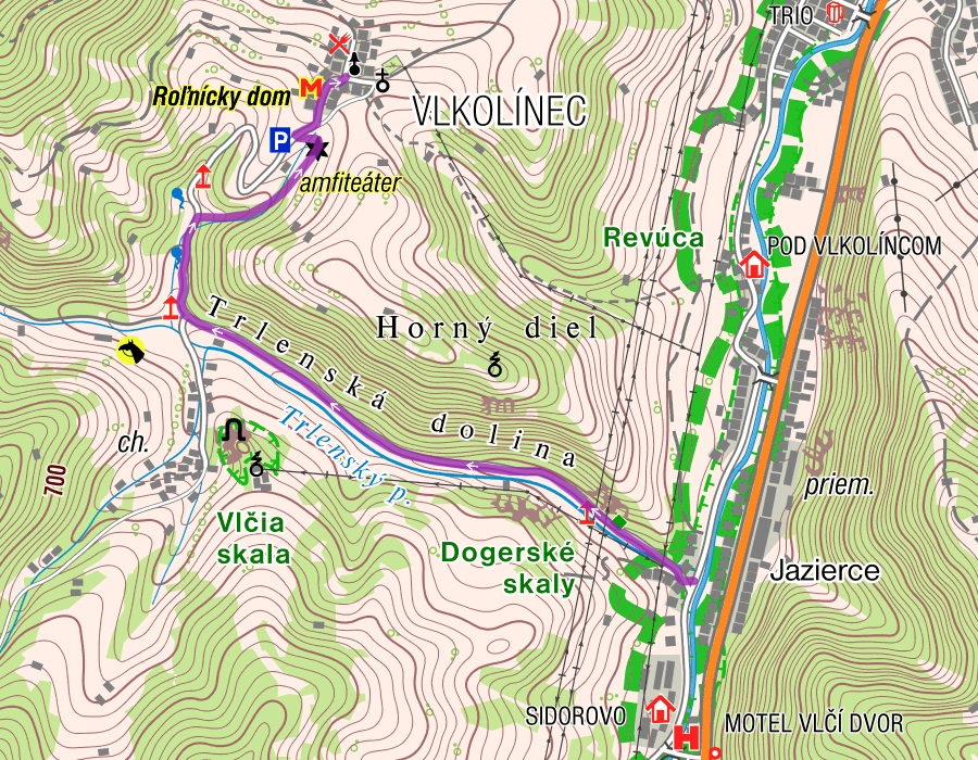
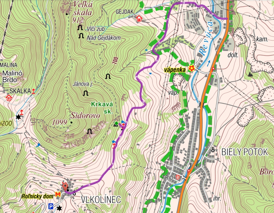
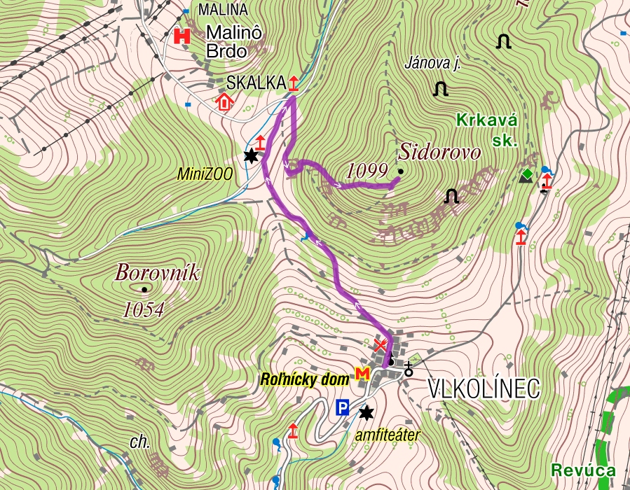
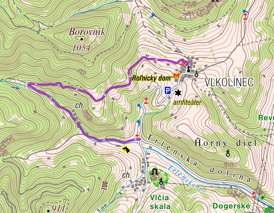
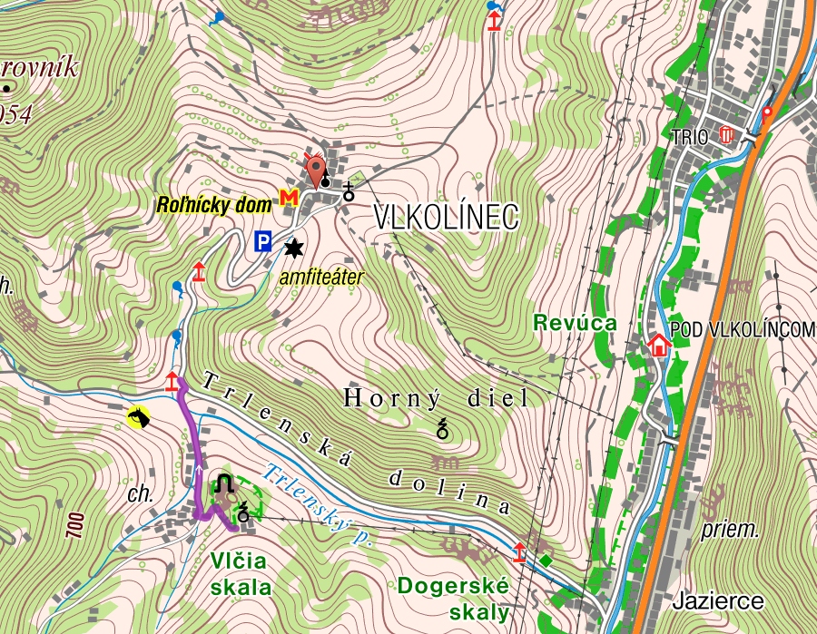
Vlkolínec is a settlement located in the foothills. It is a conservation area of folk architecture and remarkably well-preserved residential complex, consisting of log buildings typical for Central Europe. Vlkolínec has been included in the UNESCO World Heritage List since 1993. Nature trails built in its surroundings complement the whole area under the peak of Sidorovo.
Parking is generally available, regardless of the place where you join the nature trails (Ružomberok, Biely Potok, Vlkolínec). You can also park directly in Vlkolínec, but the car park is paid.
You can get some refreshments in the garden of the Folk Art Gallery in Vlkolínec where there is also a grocery open in the summer season. Food facilities are available in Ružomberok as well.
You can have a stay either in several wooden lodges and cottages in Vlkolínec or in the vicinity of Biely Potok at the beginning of the trail.
ROUTES:
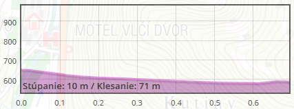
Route nr.1 | Ružomberok Biely potok – Trlenská dolina – Vlkolínec (2,8km)
Route nr.2 | Vlkolínec – Krkavá skala – Ružomberok (4,5km)
Route nr.3 | Vlkolínec – Vrchlúky – Sidorovo (1,5km)
Route nr.4 | Vlkolínec – Laz – Močidlá – Trlenská dolina (2,4km)
Route nr.5 | Vlčia skala – Trlenská dolina (0,8km)
Route Nr.1 | Biely potok – Trlenská dolina – Vlkolínec (2,8km)
Route Nr.2 | Vlkolínec – Krkavá skala – Ružomberok (4,5km)
Route Nr.3 | Vlkolínec – Vrchlúky – Sidorovo (1,5km)
Route Nr.4 | Vlkolínec – Laz – Močidlá – Trlenská dolina (2,4km)
Route Nr.5 | Vlčia skala – Trlenská dolina (0,8km)
The Zlatnica nature trail runs in between the villages of Nižná Boca and Vyšná Boca. The 8-kilometre trail was developed in 2004 and consists of 11 stops with information boards. It focuses on mining history and the surrounding culture. It is available throughout the year for pedestrians and cyclists. At 11 stops you can learn about the history of mining, local attractions and nature. The Zlatnica nature trail passes through the localities Pod Oleškovou, V Kiari, V Kúte, Geplovô, Ochimstál, Pri Mlyne, and follows along the mineral spring of Kyselka, a shepherd´s hut and evangelical churches in Vyšná and Nižná Boca.
If you are looking for a simple trip with children, the nature trail will be an ideal choice for you. Also, the village of Nižná Boca is worth seeing, and especially the observation tower Krajčov Vrch, which keeps an eye on the village from about 1000 meters above the sea level.
The parking space is limited. Free parking is available only on local roads in the villages Nižná Boca and Vyšná Boca. Bus lines from Liptovský Hrádok and Liptovský Mikuláš circulate regularly to both villages.
Several smaller accommodation and food facilities are available in the villages Nižná Boca and Vyšná Boca. Further facilities are available in the locality of Čertovica. There is also an acidulous mineral spring offering refreshment.
The Demänovská Ice Cave is one of the only natural phenomena in the world. Its beauty is admired by thousands of tourists from all over the world every year. This natural attraction is accessible by about 750-meter long serpentine walkway supplemented by information boards, forming a nature trail. The boards were created and operated by the Správa slovenských jaskýň (Slovak Caves Administration) and therefore they are thematically focused on local natural conditions (forest communities, animals or the cave system). Written information on the boards are in Slovak, English and German.
The linear, self-service nature trail focusing on natural science and conservation is located in an attractive tourist area and contributes appropriately to the environmental education of the public. This easy – medium demanding and self-guided trail runs along a serpentine access path to the cave, and from the parking lot, it can be completed in half to three-quarters of an hour.
Regular bus service is available on the route Demänovská Valley and Liptovský Mikuláš, which is relatively well-timed to meet the tourists´ needs. The starting point is situated at a bus stop. There is also a spacious car park, for which visitors are charged during the summer season.
At the beginning of the nature trail, there is a hotel and the Riverside Restaurant where you can refresh yourself. The widest selection of accommodation and gastronomic facilities within the Liptov region is directly in the Demänovská Valley.
The nature trail concludes a very popular route leading up to the cottage in Žiarska Valley. It consists of 15 boards that provide visitors with information on local history, fauna and flora, and local sports. The trail also includes rest areas with benches and shelters in case of bad weather.
The first stop is in the mouth of Žiarska Valley near the Mine and there are three themes mentioned on the boards (Žiarska Valley; short history of the village Žiar; inhabitants of the village Žiar during the wars). The second stop is situated at the third bridge, and two more are found below the locality of Hladké and near Mláky, where the trail meets the original old way to the cottage of Žiarska Chata. Themes are as follows: fauna, flora, Smrečianka stream, mountains, avalanches and sheep breeding. The last stop is at the cottage of Žiarska Chata with the following themes: the former cottage of Žiarska Chata and downhill skiing history. The accompanying articles, which are both in Slovak and English, also contain photographs. Žiarska Valley is one of the most visited valleys of the Western Tatras. The natural beauty and easy accessibility make it favourite for visitors – it is only 12 km away from the centre of Liptov – Liptovský Mikuláš town. The end of the valley is formed by massive peaks and ridges. Visitors to the valley, tourists, members of school and family trips will appreciate information on the boards which are placed in the heart of the peaceful, untouched Tatra Mountains countryside.
There is a paid car park at the beginning of the trail at the mouth of Žiarska Valley. There is also a bus stop near the car park. The bus service circulates from/to the town of Liptovský Mikuláš.
There are accommodation and food facilities within the local infrastructure at the beginning of the route and in the cottage of Žiarska Chata at the end of the route.
The Demänovská Cave of Liberty (Slov.:Demänovská jaskyňa Slobody) is one of the most visited natural attractions in the region. It is visited annually by thousands of local and foreign tourists. The cave is situated approximately half-way through the Demänovská Valley and its entrance is accessible from the main road along a 500-metre serpentine pathway.
It is an easy blue marked trail complemented by a nature trail with 6 information boards prepared for visitors by experts from the Správa slovenských jaskýň (Slovak Caves Administration) focusing on natural science and underground karst formations and National Nature Reserve Demänovská Valley. They present the origin and basic features of karst phenomena, the expansion of the karst and accessible caves in Slovakia, as well as natural values, discovery and access to the Demänovská Cave of Liberty.
The linear, self-guided nature trail focusing on natural science and conservation is located in an attractive tourist area and contributes appropriately to the environmental education of the public and can be completed in less than half an hour.
Regular bus service is available on the route Demänovská Valley and Liptovský Mikuláš, which is relatively well-timed to meet the tourists´ needs. The starting point is situated at a bus stop.
At the beginning of the nature trail, there is a hotel and the Riverside Restaurant where you can refresh yourself. The widest selection of accommodation and gastronomic facilities within the Liptov region is directly in the Demänovská Valley.
Starting from the village of Východná, the route will take you past the amphitheatre to the ponds. Walk through the underpass under the railway, from where you follow the forest foopath that first runs alongside the railway track, later turns left and starts climbing gently. The path will lead you along several raised hides, where you can pause in the evening and – with a bit of luck and patience and enough time – you might see forest animals. The route starts climbing more steeply and it snakes through the woods before it brings you to an asphalt road. This is where you turn left and continue ascending to the water reservoir, where you will be rewarded with spectacular views over the whole Liptov. In the distance you will see Chočské vrchy mountain range, on your left there will be the Low Tatras and on your right the Western Tatras and the High Tatras.
You can park in the Východná village. The village is also accessible by bus or train.
There are various accommodation and dining options in the village of Východná.
The town of Liptovský Hrádok is Skalka. The undemanding route will take us to its top. From where we can see the whole city, the river Belá, but also the surroundings of Liptovský Hrádok. On the top of the hill we find a double cross and under Skalka there is a memorial with a memorial plaque dedicated to the victims of the 1st and 2nd World War, inhabitants of the villages of Belánska dolina. The monument was built by L. Pollák – an academic sculptor.
Parking is available just below Skalka and is free of charge. Regular bus connections to Liptovský Hrádok.
Catering and accommodation is possible in the town of Liptovský Hrádok or Hotel Grand Castle Liptovský Hrádok is located directly opposite Skalka.
Chata pod Náružím (Červenec) is situated in the lap of the beautiful West Tatras scenery, surrounded by peaks of Babky, Malá Kopa and Veľká Kopa, and peaks Ostrý Vrch and Sivý Vrch. The trail starts at the beginning of the valley of Bobrovecká Dolina, specifically in the locality of Bobrovecká Vápenica (lime kiln) where there is a free car park. The route runs along a blue marked trail through a Calvary and along a gravel road, then through the crossroad Pod Babkami, and continuing through the forest road to the cottage of Chata pod Náružím.
The most beautiful yet physically demanding access road leads from Bobrovecká Vápenica along the blue trail. There is an unmarked footpath in the forest leading through “Biele Studnice” (White Wells), then between the rocks of Mt Sokol and Mt Mních (the most demanding section secured by chains) and connecting to the main access road in Nižný Červenec (15 min. to the cottage). We recommend that you take this trip only with an experienced guide.
Directly at the starting point of the trail in Bobrovecká Vápenica, there is free parking with sufficient capacity. The bus stop is situated about 2.5 km by walk from Bobrovecká Vápenica, at the crossroad with the village Jalovec, where you can get by suburban line from Liptovský Mikuláš.
You can refresh yourself or spend a night at Chata pod Náružím. Near the starting point of the trail, there is Horský Hotel Mních (Mountain Hotel Mních). On the way from Jalovec it is possible to visit the shed Salaš Pastierka. Moreover, there are reserved camping sites.
Cottage Magurka is one of the modern cottages with a relatively large capacity of beds and with quality services (sauna, tub, and restaurant). It is also accessible by car using an asphalt road which is also a great place for walking and visiting the cottage. The cottage itself is located in the former mining settlement Magurka, in the beautiful natural environment of the Low Tatras at the end of the valley of Ľupčianska Dolina under the peaks of Latiborská Hoľa (1648 m), Ďurková (1749 m) and Chabenec (1955 m). We can find other dwellings or a church in the settlement.
In summer you can make full use of three marked hiking trails – blue, yellow and green which fork to the main ridge in Magurka. The way back in the opposite direction along the green trail is also very nice. It runs through Železnô to Salatín offering beautiful views.
There is an official car park in the valley. Parking is only possible along the road around Tajchy (artificial water reservoirs) but visitors can also use public transport at the starting point.
You can stay directly in the cottage offering double to five-bedrooms with an extra bed or in family bedrooms with two separate rooms. All rooms have their own sanitary facilities . Beverages and food are also available in the Chata Magurka cottage.
During your tour around the Liptov region, we recommend that you also visit the mountain village of Pavčina Lehota located on the northern side of the Low Tatras, at the entrance to the Demänovská Valley. There is an educational path with 11 learning points stretching about 10.5 km across the village and its surroundings. An observation tower with a unique view of the entire Liptov region is part of the path. The tower is just a few minutes’ walk from the car park in the ski resort Žiarce. The road to the tower leads across a meadow and still offers views of the surrounding area. There is also a mountain bobsleigh track at Žiarce which is undoubtedly a great attraction for adrenaline enthusiasts.
A free spacious car park is available at the ski resort Žiarce. Bus service is available from Liptovský Mikuláš to the village of Pavčina Lehota.
Accommodation facilities are either available in the village of Pavčina Lehota or in the nearby Demänovská Valley, just like quality food facilities.
Vavrišovo is a village located near the town of Liptovský Hrádok, close to the D1 motorway entrance. The village is one of the most beautiful in the region, also due to unique barns with exceptional architecture that complements the whole landscape. The Museum of the Battle at Vavrišovo was built in memory of the battle that took place on the territory of the village in August 1709 as part of the uprisings of František II. Rákoci between the rebels (kuruc people) and imperial army (labanc people). During the battle Vavrišovo was burned. The museum also has an observation tower providing you with an exceptional view of the village, the Western and Low Tatras, peaks of Kriváň and Ďumbier, and the barns.
Parking is available next to the museum and it is free of charge. Regular bus link circulates between the town of Liptovský Hrádok and the village.
Food and accommodation facilities are available in the village and also in Liptovský Hrádok.
(Náhľad mapy: hiking.sk)
St. John’s Lookout Tower rises above the village of Liptovský Ján and offers views of the entire village and wide surroundings. The lookout tower is wooden, its shape and used materials are based on traditional Slovak architecture. Located in Stráne above the cemetery below Kameničná Hill (829 m above sea level).
You can reach it directly from the village or from the thermal spring area Teplica (via the Štiavnica brook). There is a simple walkway leading to the observation tower, which starts from the nearest road near the cemetery, where it is possible to park but in limited mode. The route is unpretentious with minimal climb. It is therefore suitable for both children and seniors.
Free parking is available within the village of Liptovský Ján. At the starting point of the walkway to the lookout tower, parking is limited to the minimum number of vehicles. Regular bus service runs from Liptovský Mikuláš to Liptovský Ján.
Catering and accommodation is possible in the whole Jánska valley. Where you will find restaurants and traditional cottages.
You can learn more about Jánská dolina on the Jánska dolina website.
The observation tower on Sousava Hill is a 16-meter-high view point, which allows the mountains of Rohace, Choc Mountains and Mala Fatra as well as Orava Magura and Babia Mountain to be seen over the trees.
Due to its demanding nature, the route is also manageable for smaller children. The lookout can be reached after about a half-hour walk with a 160 m climb. You can count on 45 minutes if you choose a longer route that bypasses the hill from the right side. The way back leads downhill, making it a few minutes faster. Often, the beginning of a shorter route leads to the often muddy forge due to logging. If it was raining before the trip, use a longer route around the hill for a trip.
Parking is free. Regular bus connections to Liptovský Mikuláš.
Catering and accommodation is possible in the village of Veľké Borové.
(Náhľad mapy: www.hiking.sk)
The Kvačianska Valley is a pleasant place to spend free time. A roughed and undemanding mountain path runs through it. This is why it is popular with tourists of various ages, especially families with children. However, the destination is also attractive for water mills Oblazy and two observation spots that were built just a few years ago. One of them is the Observation Platform Kobyliny – a metal structure located above the canyon of the River Kvačianka that is deep up to 70 meters. The spot is only a few minutes walk from the mouth of the Kvačianska Valley where you will be led by the red marked trail.
There is paid parking right at the mouth of the valley. Regular bus links circulate to Kvačany from Liptovský Mikuláš.
Food and accommodation facilities are available in the village of Kvačany. There is also a buffet at the car park at the mouth of the valley.
(Náhľad mapy: hiking.sk)
A wooden cottage with an observation tower was built in the village of Nižná Boca just recently, in 2014. For its height of 14.5 metres and a unique location in the arms of nature as well as an amazing view of the minig settlement and the valley of Bocká Dolina the observation tower became a popular finish point of tourists. To reach the tower, take the path leading through the village. It is an easy tour taking just a few minutes. At the top of the tower you will get familiar with the history of the village and the photo documentation with the description will provide you with information about the surrounding hills. The cosy mountain cottage providing accommodation as well as a garden house with sheltered fireplace are part of the observation tower.
The cottage can sleep about 10-15 people on mattresses using own sleeping bag in two rooms upstairs. Downstairs you can find a fully-equipped kitchenett, a small stove, a fireplace and a toilet. There is water and electricity in the cottage. The whole cottage can be rented year round but in winter the access to the cottage is much more complicated due to snow.
Free parking is available in the village of Nižná Boca. At the starting point of the route there is also a bus stop. The village is reachable by bus from the town of Liptovský Hrádok. During the observation tower opening hours you can also get some refreshments. Food service is not provided in the property.
Food and accommodation facilities are available in the villages Nižná Boca and Vyšná Boca as well as in Malužiná.
(Náhľad mapy: hiking.sk)
We start the tour in the centre of Ružomberok – at Andrej Hlinka Square – from where we continue through the local Calvary to the ski resort of Malinô Brdo. There we will take the blue hiking trail and continue through the Čutkovská Valley. The valley is one of the most favourable tourist spot for relaxation not just for Ružomberok inhabitants but also for the tourists all over the world. It is a great place to take a rest in the countryside mainly sought-after by families and children.
Food facililies and parking places are also available in the locality as well as bus links to Ružomberok where we started our tour. The nearest bus stop is located only 5 minutes from the end of the valley, just at the main road.
There is a hut offering traditional Slovak cuisine in the valley, and you can find several food facilities also in the ski resort.
It is undemanding hiking trail starting at the cable car valley station in the resort of Malinô Brdo also called Hrabovo. There are no problems with parking as well as to find food facilities in the locality. Also a rope course Tarzania is situated here as well as a water reservoir with a possibility to rent a boat. The trail starts at the yellow marker that is leading to the local Calvary and continuing onto the well-known meadows of Vlkolínske Lúky where you can admire the majestic rock formations and the surrounding mountains. A slight climb will lead us to the jewel of the entire region protected by UNESCO – Vlkolínec. This historical area is a sought-after place for tourists from around the world. We are returning back along the same trail to the car park in Hrabovo.
In Hrabovská dolina, you can park comfortably and for free in the parking lot right next to the cable car boarding station. The hike from Hrabov, through Kalvária, Vlkolínske lúky to Vlkolínec (720 m.a.s.l.) takes approximately 1.5 hours. You can make a pleasant walk easier by taking the cable car, which will save you an hour of travel. You can get from Vlkolínec this way again (by cable car or on foot through Vlkolínske luky and Kalvária) or the other way through Trlenská dolina to Biele Potok.
Public transport line No. 5 runs to Hrabov from the bus/railway station and Rybárpole railway station in Ružomberok. The line stop is located directly at the main parking lot, where the starting point of the route is also located.
Parking options are also sufficient in the free parking lot at the valley station of the Malinô Brdo cable car or in the lower parking lot, where the second bus stop is located.
You can pass the night either in the valley of Hrabovská Dolina or at Malinô Brdo or directly in wooden huts and cottages in Vlkolínec. All the three places offer refreshments during your hike.
(Náhľad mapy: hiking.sk)
Žiarska Chata situated in the middle part of the valley of Žiarska Dolina is the only alpine cottage in the West Tatras. It is very often visited by tourists as it is a starting point for different hikes up to Mt Baníkovo and Mt Baranec. It is attractive for families with children, seniors and less experienced tourists, as well as cyclists. The trail to the valley of Žiarska Dolina starts at the mouth of the valley where there is a paid parking place. The whole trail runs along an asphald road with a possibility to turn onto an old tourist trail through the forest. A pleasant, smooth climb is complemented with the cave of Medvedia Štôlňa, especially attractive to children.
Parking is available at the mouth of the valley of Žiarska Dolina for some fee. Guests staying in the cottage are allowed to drive their cars to the cottage to park their car on a car park.
Good accessibility is also ensured by local bus transport from Liptovský Mikuláš. The final bus stop is located approximately 400 m from the trail´s starting point.
At the beginning of the trail there is a cottage Kožiar offering drinks and food. Žiarska Chata cottage itself also offers background for its visitors.
Map preview (Hiking.sk)
I parked my car at the end of the village near the wooden bell tower, which turned out to be the ruins of a 13th-century church that burned down in 1805. We first turn into the last street in the village, but here the map fools us and the path simply ends at a gate, behind which the owner was shouting at some barking dogs and, apparently for the fourth time, had to explain that the real route is higher up the slope. You just need to walk a little deeper into the valley.
Steep paths to Jánošíkov stôl
This time, from the correct slope, an inconspicuous path turns upwards. I check the map just in case, and we follow it. After the downpour the night before, the clay surface is a little slippery. After a while, another joins from the right and, to my surprise, there is a red mark on a tree. I don’t know where the route starts, but this explains why the trail is so well trodden. It should be added that it is relatively steep. We are sometimes offered a view of Liptovská Mara through the trees. The ascent is strenuous but I enjoy it immensely because the forest smells of the night’s rain and the greenery is breathtaking – after all, we are in Liptov in mid-July!
We steadily climb, pass a distinctive rubble field and then an impressive rocky cliff appears overhead. I explore this intriguing wall but don’t see any pitons or ropes anywhere – perhaps nobody climbs here. A cross appears above, and the heated rock really resembles a table, or rather it creates a very comfortable bench, ideal for a picnic. The end of the red trail is marked on the rock, but there is no signpost anywhere. While we are rooting through our backpacks for food, I am haunted by the thought of the inconspicuous path that continued further into the Čerenová massif before the turn to the rock terrace. On the one hand, I am not excited by the idea of descending the same path, and on the other, I feel like a bit of improvisation. On the digital map, I find an unmarked but distinct trail that runs along the hillside and only slightly crosses the contour lines.
Hunting trail under Čerenová and Lomné
I hear thunder somewhere above Veľký Choč and the weather forecast says there is a threat of occasional showers and storms, but this one will miss us. I continue along an inconspicuous path from the saddle behind the rock. It climbs steeply at first, so I start harbouring doubts, but then turns to the left and follows the contour line as it should. The map wasn’t lying. This trail is like something out of the most secret dreams of a tourist!
It is not entirely clear to me how it originated, but I assume it was used by hunters or gamekeepers in ancient times. In some places they have employed pickaxes and shovels, while in others it is quite inconspicuous, created only by the walkers’ feet and overgrown with juicy grass. It steadily climbs, yet the slope is mostly pleasant and the wilderness is pure heaven.
Several sections lead directly above rock walls, so the route requires some concentration. I probably wouldn’t take small children here, as the chasms under our feet sometimes take our breath away. I whistle and sing because this is the perfect place to meet a bear. According to the head of one national park (a bear expert), they like to hang around hunting trails because this means they can move around without using too much energy and they are not disturbed as often as on marked hiking trails. Those prints in the clay I see are just deer, but we don’t want to take risks, especially where we cannot see around the corner, and so we make loud noises to make sure we don’t surprise anything. I check our progress on the map from time to time and we are making decent progress. At one point we see Veľký Choč through the trees and over the neighbouring ridge. Here and there the surface of the narrow path is clay, at other times needles and roots, often grass and occasionally gravel. When we are below the peak of Lomné, the trees part and we see into a clearing revealing the impressive amphitheatre at the end of the Annina dolina valley. Clouds are gathering just over the ridge, along which the green hiking trail runs.
Biblical rain
We rush through the clearing, but here the terrain is the most treacherous. The vegetation rises above our knees and in places even up to our armpits, and the tall grass conceals branches left after logging, stones and other hazards. We are continuously searching for the trail as it keeps disappearing, but a little further ahead I see a clear line that will lead us to the saddle of Rovne between Lomné and Heliaš. We have mostly been heading north so far, but here we change direction towards the west and I have to say the sky looks slightly apocalyptic. It darkens and the rain arrives almost like an advancing wall. We shrug off our backpacks and put on our waterproofs. As expected, we link up with the green trail and normally we would follow it to Pravnáč and the car, but in this downpour we just look for the shortest way to the valley.
The forest path turns into a stream of dirty water, but in the end the downpour does not last even half an hour. At its narrowest point, the path is cut into the rock, over which water pours. Our wet things are steaming. Purple bear droppings on the road confirm that we were right to be cautious – clearly blueberries were on his menu.
Before long, the world is once again bathed in summer sunlight, as if the whole downpour were just a dream, leaving behind only fragrant air. I look towards the slope of Čerenová and realize that our route has led us over white rocks that rise in many places along the steep slope. Only a few hours ago, I had no idea about the existence of this amazing trail down the mountainside, and it was only some strange coincidence that gave us the opportunity to get acquainted with this creation in the unforgettable nature of Liptov, previously unknown to us. There are doubtlessly more such hidden treasures of inconspicuous unmarked trails, and perhaps we will get to see more of them (www.hiking.sk).
Starting point: 49.150079, 19.467067
Free parking is available in the village.
By train or bus to L. Mikuláš and then by bus from L. Mikuláš to the village of L. Anna. – timetable.
In the village of Liptovská Anna there are only a few accommodation facilities and these are quite small (private accommodation). We recommend staying in nearby villages, such as Bobrovník, Liptovská Sielnica, Potok, or Bešeňová. Food is available in both summer and winter in the surrounding villages in hotel restaurants, guest houses or huts.
A panoramic view from Mt Poludnica (1549m) is unforgettable. You will have the whole region of Liptov at your fingertips and believe us, it is not a difficult tour at all. The tour begins and ends in the village of Liptovský Ján, at the car park and bus station in front of Hotel Ďumbier where the green trail starts. From the very beginning, the trail is ascending steeply across two ski trails which are part of the local ski resort. From the top of the hills you can enjoy amazing views of the Liptov region. The trail continues up to the saddleback of Rakytovica and further along a steep yellow marked path towards the locality of Predná Poludnica. The trail is rugged, full of panoramic views of Liptov and rocky formations that are reachable from any place along the whole section. There is another steep climb along a cave in which, according to a memorial tablet, about 40 Jews from Slovakia and Poland were being hidden from autumn 1944. All of them survived thanks to inhabitants from the village of Závažná Poruba who helped them despite risking their own lives. The following location is Predná Poludnica with excellent panoramic views of the water reservoir Liptovská Mara and the Western Tatras from where it is just a few steps to the peak of Poludnica (1549m). We will get back along the same trail or we cann prolong it along the blue trail towards the locality of Kúpeľ, and from there along the green trail back to the saddleback of Rakytovica.
The bus station is directly at the starting / finish point of the tour. You can get there by bus with direction Liptovský Mikuláš to Liptovský Ján. The parking space is also suficient and free of charge.
There is neither mountain cottage nor lodging house in the vicinity of the trail to offer some food and bed. But directly at the car park there is a buffet and a restaurant – a traditional shepherd´s hut – which offer local specialties and accommodation. But there is a wide selection of year-round accommodation and food facilities in the village of Liptovský Ján.
Map preview (Hiking.sk)
The story of water is a modern experiential trail designed especially for families with children. It is located in the lower part of Demänovská Valley, and in its entire length, it passes through the riverbed of the Demänovka stream. Visitors will learn interesting facts about the water element and its natural significance through educational boards and stops. What´s more, they can recharge their batteries in rest places.
The trail is 4 kilometres long and not demanding. The whole trail is divided into two imaginary parts with regard to access possibilities and attractiveness. The first part leads from the Hotel Bystrina (bus stop) to the Hotel Chopok, where the route passes smoothly to the other side of the flow through a wooden bridge. This part of the route is more attractive and leads from the Chopok Hotel around the Demänovská Ice Cave to the most visited Slovak cave, the Demänovská Cave of Liberty.
Demänovská Valley is connected with Liptovský Mikuláš by regular bus service, which is relatively well-timed for the needs of tourists. The starting point of the tour is located right at the bus stop as well as at the finishing point. There is also an official car park at the starting point. It is free with sufficient capacity.
While ascending the nature trail, you can refresh yourself right at the beginning of the nature trail in hotels Bystrina, Tri studničky and Chopok, or in the Restaurant Riverside.
The widest selection of accommodation and gastronomic facilities within the Liptov region is directly in the Demänovská Valley.
Mt Baranec (2184m) is a peak overlooking Liptovský Mikuláš. Along with Mt Kriváň, it is a dominant part of the town’s panorama and undoubtedly one of the most visited peaks of the Western Tatras and the region of Liptov. The reason is that the trail leading to Mt Baranec can also be a circle, complemented by a stop at the cottage of Žiarska Chata.
The tour starts at the paid car park at the mouth of Žiarska Valley, from where you take a steeper ascent along the yellow trail up to a forest and a fork of Holý Vrch (a peak) offering stunning views of the whole region of Liptov. After reaching the peak of majestic Mt Baranec (2184m) you will take an easy descent through Smrek up to the saddleback of Žiarske Sedlo (1917m) and then a steeper descent along the green and blue trail through the Žiarska Valley towards he cottage of Žiarska Chata. There you can get some food and drinks all the year as well as use accommodation services. From the cottage you have various options where to go hiking. You can continue downwards along an asphalt road or use the blue former hiking trail through the forest with an educational path or you can rent a scooter to get down to the car park – your finish poin
You can park on the paid spacious car park loacated at the mouth of the valley. You can also use the local bus service from Liptovský Mikuláš. The end bus stop is located approximately 400m from the starting point.
There are several food and accommodation facilities in the village of Žiar and the Žiarska Valley. At the beginning of the trail there is the cottage of Chata Kožiar providing accommodation and food as well as the cottage of Žiarska Chata which is situated at the hiking trail.
The route starts at the large car park for the Lúčky cable car. We follow the green hiking trail through the cottage area to the signpost, where we join the red trail. On the steep dirt road that also serves as a ski slope, a view opens of the Jasná ski resort and other peaks of the Low Tatras – Poľana, Bór(y) and Siná. Leave the dirt road and enter the forest, where you can catch your breath in a shelter and then continue over a wooden bridge along an ascending path following the creek to the Javorie sedlo. From the saddle you can follow the yellow trail in the direction of Ďumbier or the red trail towards Jánska dolina (Pred Bystrou). However, we will follow the yellow trail to the north – in the direction of Kosienky. After about 30 minutes, we will pass through Kosodrevina and arrive at the Kosienky crossroads, where we will turn north (to the left). We will arrive at the top of Krakova hoľa (1,752 m) within 30 minutes.
Starting point: 48.979859; 19.594138
There is a paid car park at the ski resort.
By train or bus to Liptovský Mikuláš and then again by bus from Liptovský Mikuláš to the Jasná Nízke Tatry resort. From here there are various transport options, whether you choose to hike or take the cable cars directly to Chopok.
At the Jasná resort there are several accommodation facilities. Food is available in both summer and winter in the hotel restaurants and snack buffets.
This very nice route starts in Smrečany. The already mentioned Gothic Church of the Sacrifice of the Lord (blessed in honour of the Purification of the Virgin Mary), the foundations of which date back to 1349, is the oldest preserved building in Smrečany. Do not miss the village museum; its permanent exhibition called „The History and the Important Personalities of the Village“ chronicles the history of the Smrečany village and displays a selection of traditional folk crafts, farm tools, folk costumes, period documents, photographs, etc. The Smrečany village merges with the Žiar village, at the end of which you will find The Chata Kožiar mountain hotel with the on-site snack bar and information boards. From the hotel, turn onto an asphalt road that will lead you to the Žiarska Chata chalet. The route can be explored on foot, by bike and there is also a possibility of renting a downhill scooter, with the road having a dedicated lane for scooters. You will see an occasional car or two. A quieter alternative to the asphalt road is an old trail through rocky forest terrain marked blue. It runs parallel to the busy supply road, but it leads through a spruce forest, providing shade from the sun. A recently renovated Žiarska Chata chalet provides accommodation with the “Tri Kopy” restaurant and an outer terrace. There are many natural beauties worth seeing just a stone´s throw from the Žiarska Chata chalet. One of them are the cascades of the Šarafiový Vodopád waterfall in the Krásno rock gully. To reach it, follow the path to Jalovecké Sedlo saddle marked with green markings that will lead you past the Symbolický Cintorín cemetary to the frothy white cascades of the Šarafiový Vodopád waterfall.
Starting point: 49.120129; 19.650750
There is a paid parking lot at the beginning of the Žiarska Dolina valley.
You can get a bus or train to Liptovský Mikuláš and then a bus to the Smrečany village or you may prefer to take a bus which stops next to the Salaš Kožiar sheep farm.
There are several accommodation options available in the villages of Smrečany and Žiar and also a number of restaurants, chalets and snack bars where you can dine in both summer and winter.
Poludnica is a very attractive peak for tourists. It rises to a height of 1,548 m above sea level and is only seven kilometres from the centre of Liptovský Mikuláš as the crow flies. These facts ensure Poludnica offers a beautiful view of the whole Liptov region. The shortest ascent is along the blue trail from the village of Iľanovo. However, even though it is only 5.5 kilometres in length, you should plan on taking at least two and a half hours to climb the almost 900 metres of elevation. You can return by the same route, or follow the yellow trail to Závažná Poruba, or continue along the blue trail to the saddle below Kúpeľ and then take the green trail to connect to the yellow one to Závažná Poruba. Our tour proposal follows the latter option. (Source: Hiking.sk)
Miesto štartu: 49.048943; 19.613448
Free parking is available in the village.
By train or bus to Liptovský Mikuláš and then again by bus from Liptovský Mikuláš and then by city bus from Liptovský Mikuláš to the village of Iľanovo.
In the villages of Iľanovo and Závažná Poruba there are several accommodation facilities. Food is available in both summer and winter in the hotel restaurants and snack buffets.
The route leads from Liptovské Revúce (Veľká Fatra) to the saddle below Čierny kameň, on past Minčol (1398) and Južné Rakytovské sedlo to Rakytov (1567). This dominant peak has a distinctive pyramidal silhouette and offers a beautiful 360° view of Veľká Fatra, the Low Tatras and, when there is good visibility, the entire ridge of the Western Tatras and parts of the High Tatras. From Rakytov we continue past severné Rakytovské sedlo to the Útulni Limba shelter, where you can purchase refreshments. The route continues through the Teplá dolina valley to the gamekeeper’s lodge and along the asphalt road back to Liptovské Revúce. (Source: Hiking.sk)
Starting point: 48.919088; 19.177596
Free parking is available in the village.
By train or bus to Ružomberok and then by bus directly to the village of Liptovské Revúce or with a transfer in the village of Liptovská Osada.
There are several accommodation facilities in the villages of Liptovské Revúce and Liptovská Osada. Food is available in both summer and winter, in restaurants, guest houses and snack buffets.
A bidirectional linear trail with 12 information panels focusing on nature protection, biology and history acquaints visitors with flora and fauna, documents the development of relief as well as anthropic influences in the most visited central part of the Low Tatras. The trail is suitable for intermediate tourists. It is a part of marked hiking trails and may be completed in less than 5 hours. A respective part of the nature trail is also accessible by a mountain bike.
Start your journey at the parking lot in front of the Grand Hotel located in the recreation area Jasná, east of the mountain tarn Vrbické Pleso (1102 m asl). Walk around the natural mountain lake along the northwest path until you come to the cottage of Mikulášská Chata. Besides the nature trail boards beneath Mt Otupné, follow the yellow tourist signs. Along the stream of Zadná Voda, you will climb up the valley of Zadná Voda to reach the fork of Tri Vody (Three Waters) (1370 m asl.), where you turn left onto the red marked trail. You will head out on the traverse along the difficult slopes of the main ridge of the Low Tatras in the Demänovská Valley. The trail slightly ascends through the northern wooded hill of Mt Dereše up to Mt Brhliská (1430 m asl.) at the upper station of a cabin cable car. The trail is slightly ascending after crossing the ski slope, and from the fork of Pod Orlou Skalou (1460 m asl.) it starts ascending more steeply. The serpentines run through scrubland onto the slopes of Mt Chopok. There is an inclined traverse that starts behind the last bend and ends at the lower station of the chair lift from Jasná to Luková. From there, the trail mostly just descends. The first section of the descent down the slope will lead you to the chairlift intermediate station (1500 m asl.) from Záhradky to Konský Grúň. From there, it further descends along the edge of the scrubland to the mountain peak of Pekná Vyhliadka (1360 m asl). Then the tour profile changes. The trail turns right and traverses through the slope to a fork in the valley of Široká Dolina (1390 m). Here you will join the green marked trail which will lead you down along the stream of Demänovka and through the valley of Široká Dolina to the fork of Pod Krčahovom (1040 masl.). Discovering the natural wonderss of the Demänovská Valley is finished at the cottage of Lúčky (925 m).
Regular bus service is available on the route Demänovská Valley and Liptovský Mikuláš, which is relatively well-timed to meet the tourists´ needs. Both the starting point and finishing point are situated directly at a bus stop. There is also a spacious car park. Parking is free of charge.
Situated at the beginning of the nature trail by the mountain tarn of Vrbické Pleso, there is the cottage of Mikuláška Chata, where you can refresh yourself. Another possibility is at the end of the trail, in the locality of Lúčky. Gastronomic facilities in the locality of Luková which are approximately half-way along the trail are not open in the summer.
The widest selection of accommodation and gastronomic facilities within the Liptov region is directly in the Demänovská Valley.
The Ostredok Lookout is located just a few minutes’ walk from the parking lot in the Biela púť location in the Jasná – Nízke Tatry ski resort. The starting point and the direction sign are also visible from the parking lot.
You turn off the main road at the cross and continue along the easy hiking route following the yellow sign. The tower was built only recently and offers tourists views of Chopok and the panorama of the Low Tatras, as well as the ski resort. There is a picnic table and benches under the lookout tower.
The hiking trail continues to the Symbolic Cemetery for the Victims of the Low Tatras and on to the Demänovská Cave of Freedom. In the chapel at the symbolic cemetery, there are tablets with the names of people who perished in the Low Tatras. There is also a statue of “Mountain Pieta”, which symbolizes a mother’s grief over the loss of a child. Inside the cemetery there is a Slovak coat of arms and a bell, which were cast by artists from Liptovský Mikuláš, as well as a monumental six-meter wooden cross, which was carved by a carver from the village of Kriváň.
Free gravel parking along the road is right at the starting point at the signpost. The starting point and the direction sign are also visible from the parking lot.
The nearest bus stop is located in Demänovská dolina near the Hotel Grand Jasná. Regular bus connections go from Liptovský Mikuláš.
Meals and accommodation are available in nearby hotels, restaurants or buffets. Demänovská dolina or the Jasná Nízke Tatry resort provides a wide range of services of all categories all year round.
(Náhľad mapy: hiking.sk)
A descent up to Mt Veľký Choč is also very attractive because we can do it from several starting points. Individual tours are possible from Valašská Dubová, Lúčky, Jasenová and Vyšný Kubín. The tour can start in Likavka, an impressive village near Ružomberok. This trail is also attractive because it is running alongside the castle of Likavský Hrad, a historical monument that is worth visiting. The trail is quite rugged, running across mountain paths and meadows. The final climb to the very top of the mountain is more difficult. A descend is planned to the village of Lúčky, where famous spa Aqua Vital Park with thermal water and wellness is situated, and also an attractive waterfall.
The trail we have chosen is reachable even by public transport. Likavka is located near the railway station in Ružomberok, where also the bus from Lúčky arrives. There is a sufficient parking place in both villages. Two cars is also a good choice; one of them can be parked in Lúčky and by another you can get to Likavka.
There are no food facilitis on the trail; we can eat first in the village of Lúčky. But we can find here two facilities for sleeping – a lodging house „Hotel Choč“ and a shelter in the locality of Žimerová.
(Náhľad mapy: hiking.sk)
The nature trail in the municipality of Pavčina Lehota created by members of the tourism association Združenie cestovného ruchu Pavčina Lehota is a place where you can spend a really pleasant day. The trail itself is not only about tourism, but also about beautiful panoramas from an observation tower, adrenaline on the bobsleigh track in the resort Žiarce, as well as about attractions listed on 11 boards that border this nature trail. Each of them contains information about the surrounding fauna and flora.
The trail runs mainly across meadows and former pastures and with a length of less than 10km and only 100m elevation, it is suitable for families with children or less savvy tourists. The trail is also suitable for cycling, and in winter it turns into a maintained cross-country trail.
The village of Pavčina Lehota is accessible by bus circulating regularly from Liptovský Mikuláš. You can also use ski buses and bike buses running through the neighbouring village of Demänovská Dolina either in winter or summer. There is a bus stop only a few hundred meters from Pavčina Lehota. A free spacious parking lot is found at the resort Žiarce at the beginning/end of the trail. Parking is also available in the village.
The route offers virtually no shade, so it is necessary to have plenty of water with you and some snack. At the beginning/end of the route, there is a buffet in the resort of Žiarce, and accommodation and food facilities are also available in the village of Pavčina Lehota.